
In Brief:
Chilly with a few low level showers Friday - a slow warm up after that.
Thursday Update:
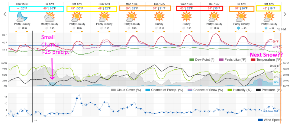
A cold front Wednesday night cooled us down for a few days (Figure 2 update). A storm that will hit, mainly, the western slopes, may throw a few rain/snow showers off the mountains over the I-25 folks and out on the plains. The Rockies to the west will appear double sized with the clouds lifting up the west side and evaporating as they descend on the eastern side. Even Estes Park may only see 1/2 to 1 inch of snow. We slowly warm to over 20F above normal mid-week. Our next 'possible' chance of snow comes NEXT weekend.
End Thursday update.
Saturday Update:
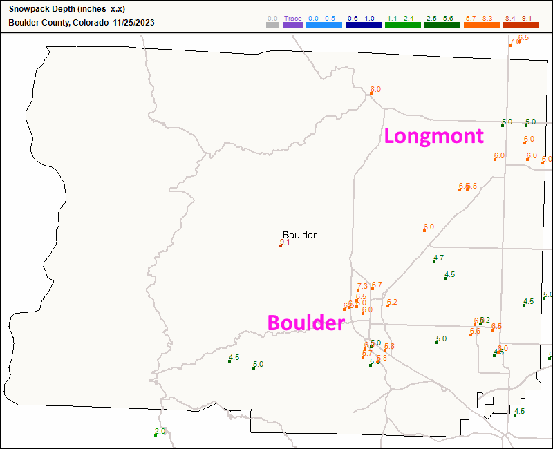
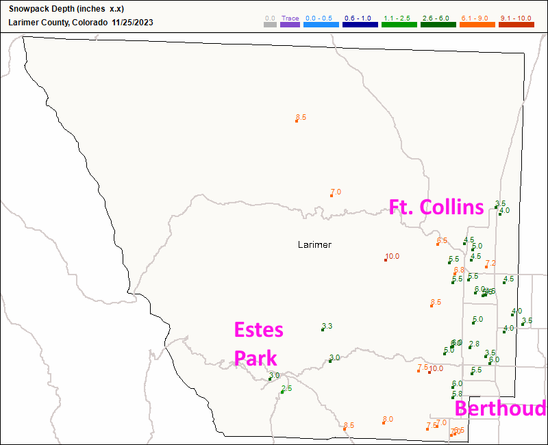
The snowfall totals for Boulder (Figure 1 update) and Larimer (Figure 2 update) counties show a strong gradient (difference in totals) from locations west of I-25 and those along or east of the interstate. Longmont picked up 5-6 inches pretty uniformly. Boulder received 5-7 inches. Areas west of Ft. Collins and Loveland picked up 8-10 inches while east of I-25, those communities saw 3.5-4.5 inches. Light snow continued after 7am, so there might end up an additional 1/2 inch or so to some locations.
Not bad for our second winter storm of the season.
End Saturday update.
Winter Storm Warning
Issued: 1:59 PM Nov. 22, 2023 – National Weather Service
...WINTER STORM WARNING IN EFFECT FROM 4 PM THURSDAY TO 5 AM MST
SATURDAY...
* WHAT...Heavy snow expected. Total snow accumulations between 4 and 10 inches.
* WHERE...Fort Collins, Boulder, and the western suburbs of Denver.
* WHEN...From 4 PM Thursday to 5 AM MST Saturday.
* IMPACTS...Travel may become very difficult due to heavy snowfall on roadways, potentially impacting return travel following Thanksgiving.
PRECAUTIONARY/PREPAREDNESS ACTIONS...
If you must travel, keep an extra flashlight, food, and water in your vehicle in case of an emergency. The latest road conditions for Colorado can be obtained by calling 5 1 1 or by going to www.cotrip.org.
Roads will be slick resulting in slow and hazardous travel. Allow extra time to reach your destination.
Forecast Discussion:
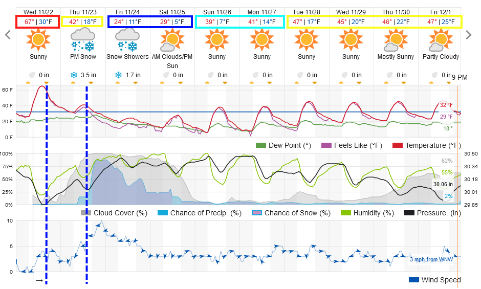
Enjoy the unusual warmth today, we are around 20F above normal Wednesday. The cold air begins to invade the state Wednesday PM and then Thursday afternoon. Temperatures will drop almost 50 degrees by Friday (Figure 1). Typical Colorado Fall weather!
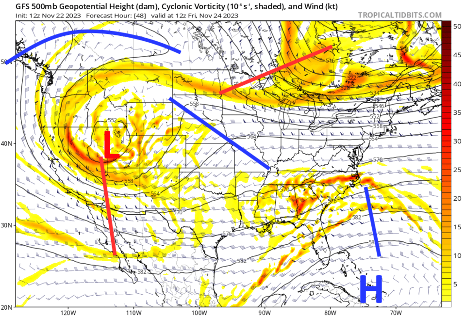
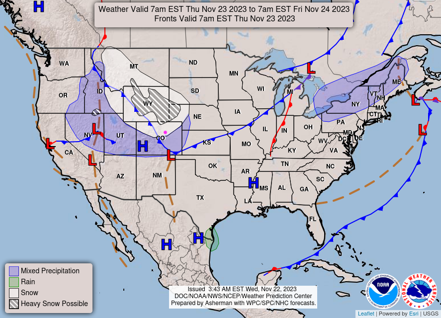
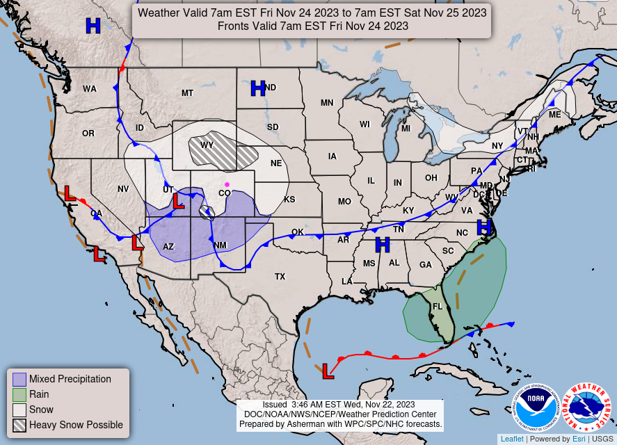
The snow should start around 5-6pm Thanksgiving evening and fall at the highest rate through Friday morning. Some ongoing snow showers are possible through Saturday morning. This storm is being powered by a large (briefly) cut-off low approaching the state (Figure 2). Moderate to heavy snow will fall on Thursday and Friday evenings (Figure 3 and Figure 4).
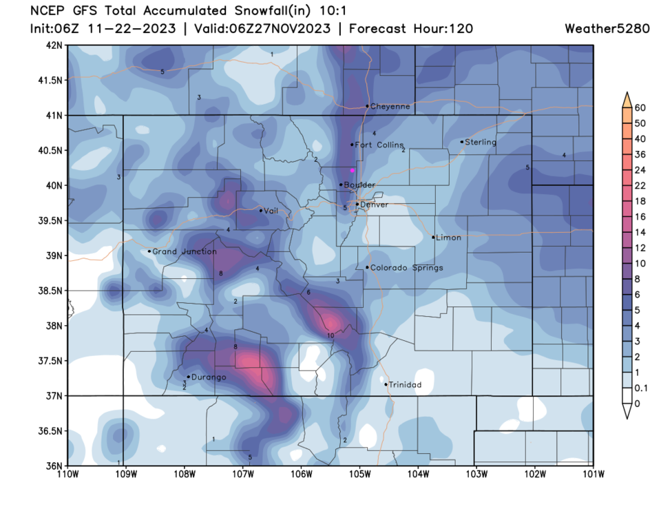
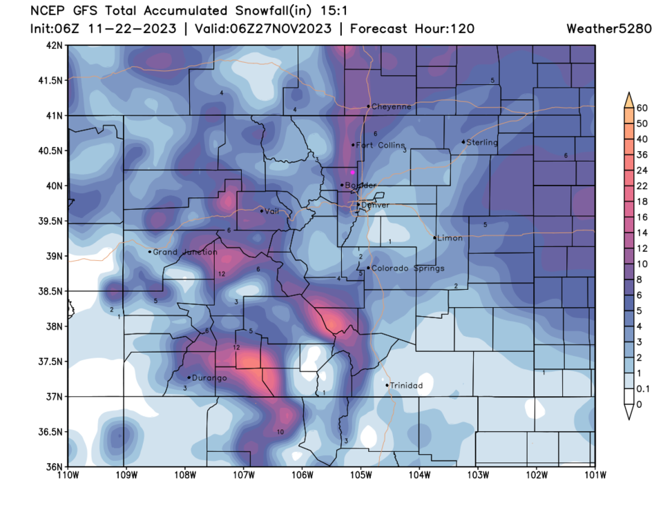
With temperatures dropping to the single digits at night, higher snowfall ratios (more like 15:1 or more) are expected. The 10:1 snowfall map is Figure 5 while the 15:1 ratio map is Figure 6. These ratios mean that 1 inch of rain would be 10 inches of snow (or 15 inches of snow for the colder temperatures).
The weather service is planning on issuing a Winter Storm Watch for snow amounts, cold temperatures, and the higher amount of travel expected around Thanksgiving. I'll post it here when it goes up.
Snowfall Roundup for Longmont:
The GFS 10:1 ratio: 4-6 inches.
The GFS 15:1 ratio: 6-10 inches.
Canadian model: 5-7 inches
NAM 10:1: 3-4 inches
Weatherundrground: 5-6 inches
Weather5280: 4-6 inches
Channel 9 news: 3-5 inches
Channel 7 news: can't find a map yet.
The Longer Range Forecast:
Beyond this storm, we slowly warm to near seasonable temperatures and remain dry to the start of December (Figure 1).

