In Brief:
Snow leaves, cool quiet week ahead.
Sunday update:
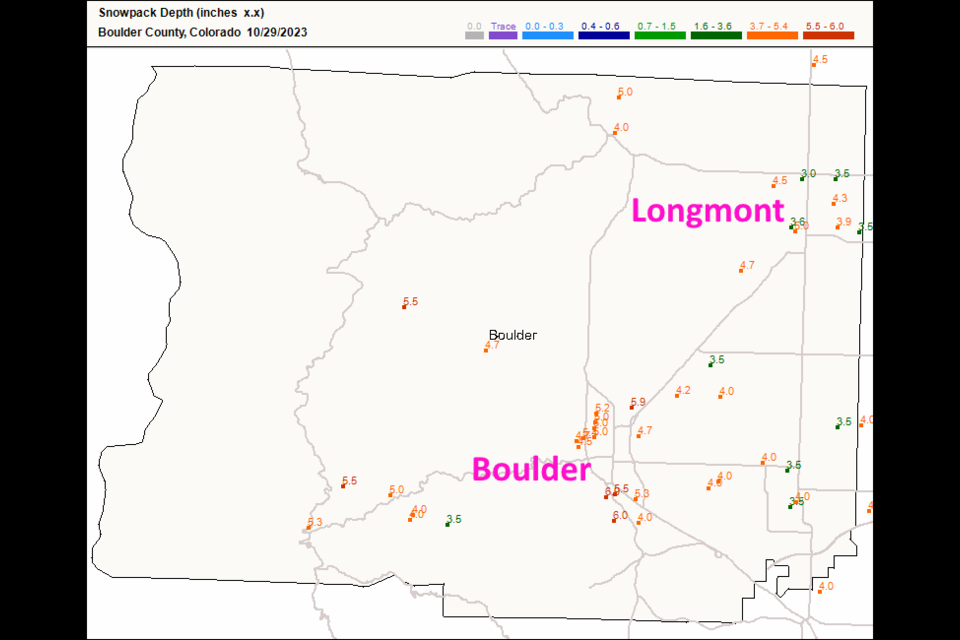
The storm has moved off to the east and northeast. Snowfall across Longmont ranges from 3-5 inches (About 1/3 to 2/5th of an inch of liquid - Figure 1 update). The week ahead warms into the 50's the 60's. Currently, our next chance of precipitation is next Monday.
Halloween Forecast:
At 7pm, the temperature will be about 31F. Winds will be out of the west at 3mph. Skies will be clear. The just-past-full moon will rise at 7:50pm. The Cherrywood Observatory will be open for Trick-or-Peek. You'll see Saturn and get candy with spooky music playing! Come to Cherrywood Drive and Cherrywood Way, not far from 17th St and Alpine.
End Sunday update.
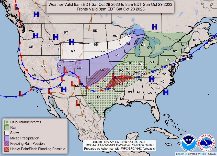
Winter Storm Warning Boulder Co. and Longmont
Winter Storm Warning
Issued: 8:45 PM Oct. 27, 2023 – National Weather Service
...WINTER STORM WARNING IN EFFECT FROM 6 AM SATURDAY TO NOON MDT SUNDAY...
* WHAT...Heavy snow expected. Total snow accumulations between 6 and 14 inches.
* WHERE...The Northern Front Range Foothills, The Southern Front Range Foothills, Boulder and the western suburbs of Denver, and Denver.
* WHEN...From 6 AM Saturday to noon MDT Sunday. The heaviest snow will be Saturday afternoon through Saturday night.
* IMPACTS...Snow covered roads will make travel hazardous and driving may become very difficult due to heavy snow, especially
Saturday night.
PRECAUTIONARY/PREPAREDNESS ACTIONS...
Persons should consider delaying travel during the heaviest snow late Saturday and Saturday night. If travel is necessary, drive with extreme caution. Consider taking a winter storm kit along with you, including such items as tire chains, booster cables, flashlight, shovel, blankets and extra clothing. Also take water, a first aid kit, and anything else that would help you survive in case you become stranded.
The latest road conditions for Colorado can be obtained by calling 5 1 1 or by going to www.cotrip.org.
Winter Storm Watch (Longmont)
Winter Storm Watch
Issued: 2:23 PM Oct. 27, 2023 – National Weather Service
...WINTER STORM WATCH IN EFFECT FROM SATURDAY MORNING THROUGH SUNDAY
MORNING...
* WHAT...Heavy snow possible. Total snow accumulations between 4 and 10 inches possible, with locally higher totals.
* WHERE...The Northern Front Range Foothills, The Southern Front Range Foothills, Boulder and the western suburbs of Denver, and Denver.
* WHEN...From Saturday morning through Sunday morning.
* IMPACTS...Snow covered roads will make travel hazardous. Travel could be very difficult, especially Saturday night.
PRECAUTIONARY/PREPAREDNESS ACTIONS...
Monitor the latest forecasts for updates on this situation.
Roads will be slick resulting in slow and hazardous travel. Allow extra time to reach your destination.
Friday Update:
Just a quick note that everything looks on track with the forecast. Some models are adding an inch or two to some locations. More later!
End Friday Update.
Forecast Discussion:
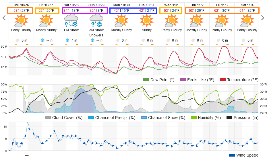
Much cooler air has arrived with a Thursday cold front (along with fog and drizzle). Reinforcing cool air arrives with another front Thursday PM with the main front moving in Friday afternoon. Temperatures are a big part of the story as well. We will be at or below freezing for the weekend. Sunday night, we should see single digits if not temperatures below zero in places. (Figure 1)
Rain/snow chances start to pick up after dark on Friday overnight into Saturday morning. Snow, heavy at times, will fall late Saturday through Sunday morning. Skies should clear by sunset Sunday (allowing temperatures to really drop).
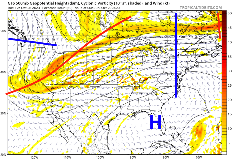
This storm is being powered by a deep strong trough approaching the region (Figure 2). At the surface, a strong low will deepen along a strong cold front (Figure 3).
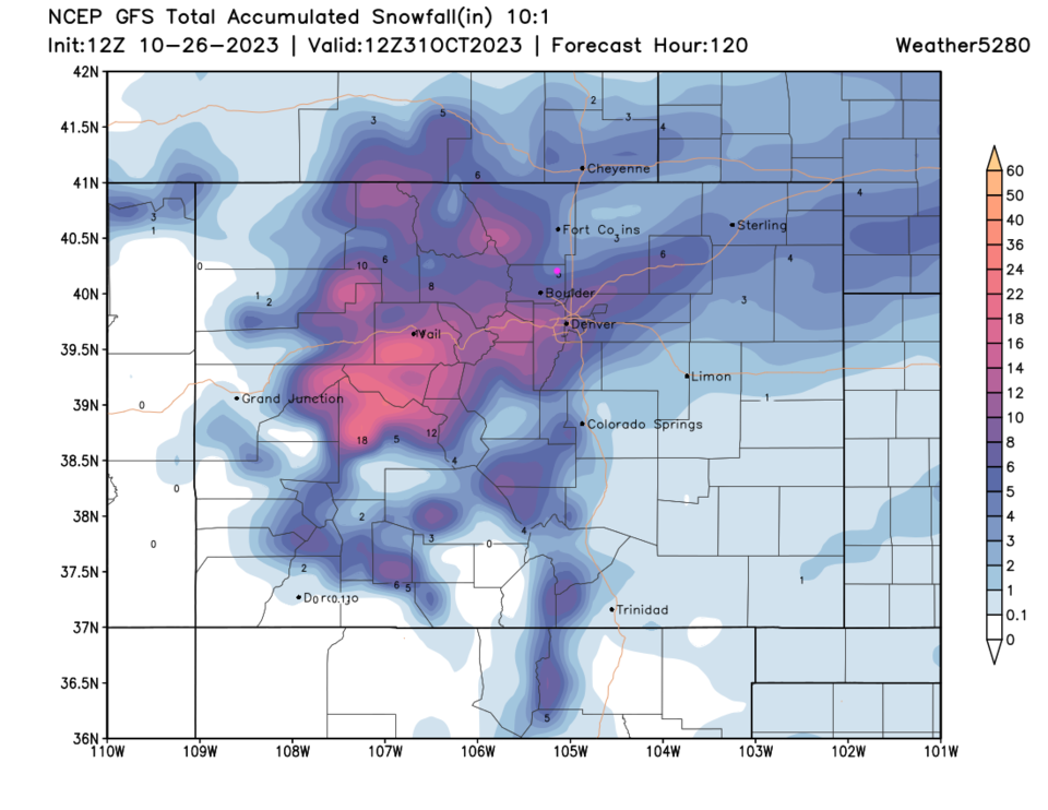
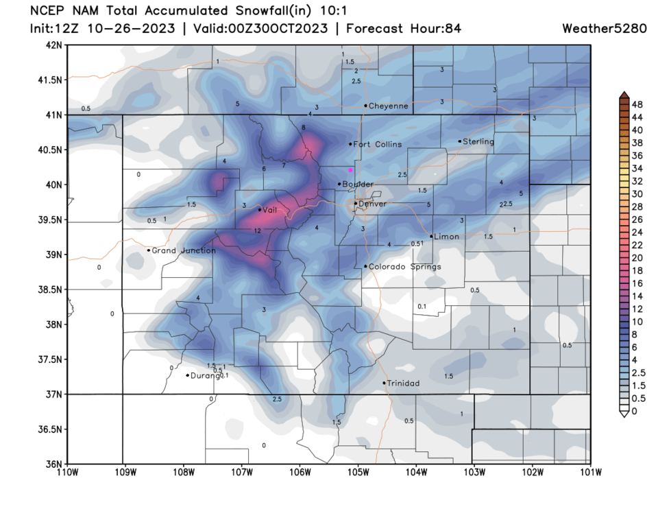
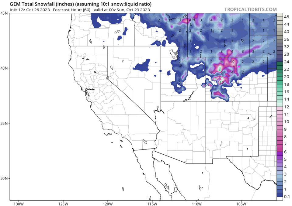
Snowfall Roundup:
The GFS gives Longmont around 4-6" (Figure 4)
The NAM gives Longmont around 2.5-3.5" (Figure 5)
Weatherunderground (Figure 1) predicts 4"
The Canadian (that is usually a bit low on its forecasts- Figure 6) paints us 2-4"
Channel 7 Denver (not shown) gives Longmont 2-6"
Channel 9 Denver (not shown) gives Longmont 5.3"
My prediction, due to duration of the event, is in line with the GFS 4-6" (especially on lawns/grass due to less early melting).
The Long Range Forecast:
After this weekend, we slowly warm to temperatures that are still below normal with no big systems/rain/snow on the horizon.

