Skip to content
Join our Newsletter

The Front Range Forecast: A more normal summer

In Brief:

Severe weather on the plains east of I-25, typical summer weather for everyone else.

The Forecast Discussion:

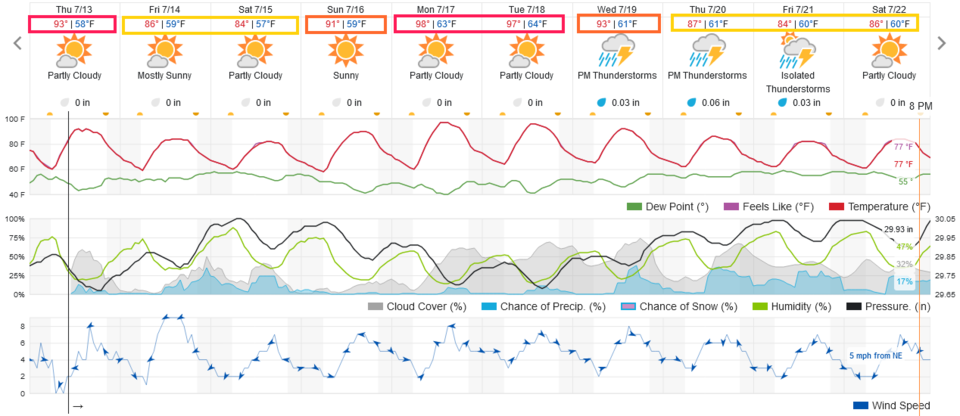
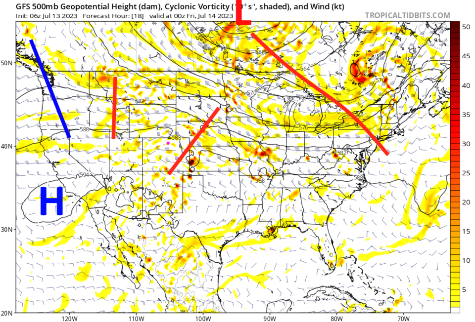
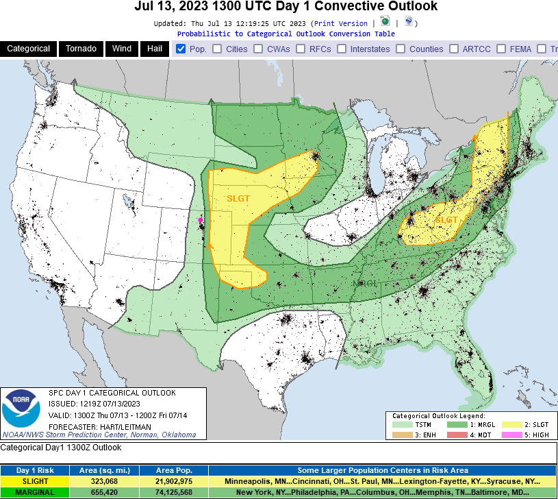
The normal high temperature for I-25 folks is 90F this week (the highest normal high temperature we see in the year). For most of the next 10 days we are close to or a bit below that except for the start of next week (Figure 1). There are low chances of an afternoon storm through Saturday with severe weather just east of I-25 Thursday (Figure 3). That is being kicked off by a ripple traveling through the upper-level flow (Figure 2 - red line over Colorado) and persistent good low-level moisture levels (high dew points).


figure1_07132023
Figure 1: the 10 day graphical forecast for Denver from weatherunderground.com
figure2_07132023
Figure 2: the 500mb upper air forecast map for Thursday evening from tropicaltidbits and the GFS.
figure3_07132023
Figure 3: the severe weather outlook for Thursday from the SPC and NOAA.

The Longer Range Forecast:

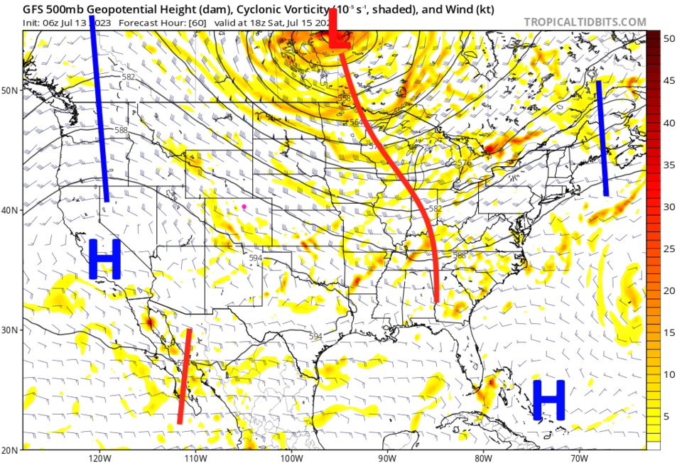
The upper air pattern evolves into a 'northwest flow' setup over Colorado after that as a ridge forms over the West (Figure 4). We can get surprise afternoon and evening storms with this pattern. The forecast may be tricky this next week. Keep an eye on the skies for storms that may 'come out of nowhere.'

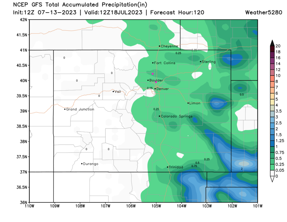
The expected rainfall over the next 5 days is light and confined to the eastern side of the Rockies (Figure 5).  I'm getting concerned about how long we have not had rain in western Colorado.  Hopefully the U.S. monsoon starts up soon and brings rain/storms back to that side of the state.

figure4_07132023
Figure 4: the 500mb upper air forecast map for Sunday noon from tropicaltidbits and the GFS.
figure5_07132023
Figure 5: the 5 day precipitation forecast from weather5280.com


About the Author: John Ensworth

John Ensworth used to work from Longmont as the PI for the NASA through the IGES (The Institute for Global Environmental Strategies). He now teaches technology, algebra, astronomy, meteorology, film school, and Lego robotics to middle/high school.
Read more


Comments


Current Weather

Cloudy

Cloudy

40°F

UV Index
0 Low
Pressure
29.98 Steady
Visibility
8 miles
Dewpoint
37 °F
Humidity
89%
Wind
SE 1.6 mph
Gust
5 mph
Wind Chill
40 °F

Hourly Forecast

Tomorrow
12 AM
39°F
Showers
Tomorrow
1 AM
39°F
Showers
Tomorrow
2 AM
38°F
Intermittent clouds
Tomorrow
3 AM
38°F
Partly cloudy
Tomorrow
4 AM
37°F
Intermittent clouds
Tomorrow
5 AM
37°F
Mostly cloudy
Tomorrow
6 AM
37°F
Cloudy
Tomorrow
7 AM
36°F
Cloudy
Tomorrow
8 AM
36°F
Mostly cloudy
Tomorrow
9 AM
40°F
Mostly cloudy
Tomorrow
10 AM
45°F
Mostly cloudy
Tomorrow
11 AM
49°F
Cloudy

7 Day Forecast

Rain and snow

Sunday

46 °F

Cloudy and cooler; rain and snow showers this morning, then a couple of brief showers late this afternoon


Showers

Sunday Night

36 °F

A few evening showers; otherwise, mostly cloudy


Mostly cloudy

Monday

60 °F

Mostly cloudy


Mostly cloudy

Monday Night

40 °F

Mostly cloudy


Showers

Tuesday

55 °F

Breezy in the morning; mostly cloudy with a couple of showers


Cloudy

Tuesday Night

34 °F

Cloudy


Intermittent clouds

Wednesday

52 °F

Breezy in the morning; otherwise, intervals of clouds and sun


Intermittent clouds

Wednesday Night

31 °F

Increasing clouds


Mostly cloudy

Thursday

44 °F

Some sun, then turning cloudy with a passing shower; chilly


Mostly cloudy

Thursday Night

31 °F

A shower in spots in the evening; otherwise, mostly cloudy


Sunrise and Sunset

Sunrise
6:48 AM
Sunset
7:23 PM

Based on AccuWeather data