Skip to content
Join our Newsletter

The Front Range Forcast: Warm, possible Christmas snow

In Brief

Very warm dry weather all week with "maybe" a Christmas Eve storm.

Forecast Discussion:

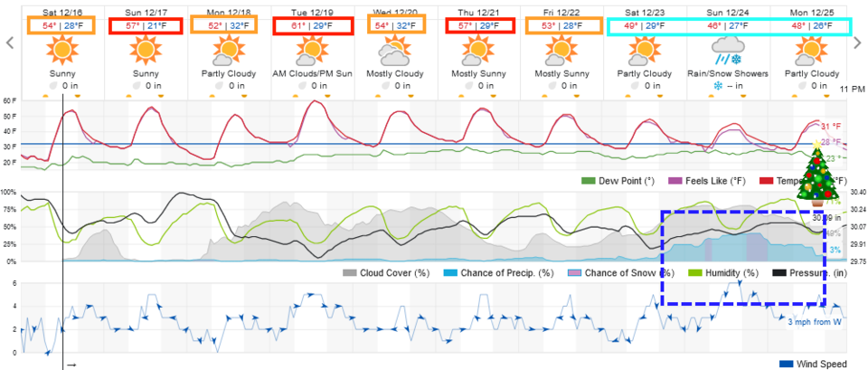
A persistent western ridge will give us really warm and calm conditions through Friday.  In Colorado, this is shorts and t-shirt weather (Figure 1). See the Longer Range forecast for what 'might' happen for Christmas.

figure1_12162023
Figure 1: the 10 day graphical forecast for Longmont from weatherunderground.com

The Longer Range Forecast:

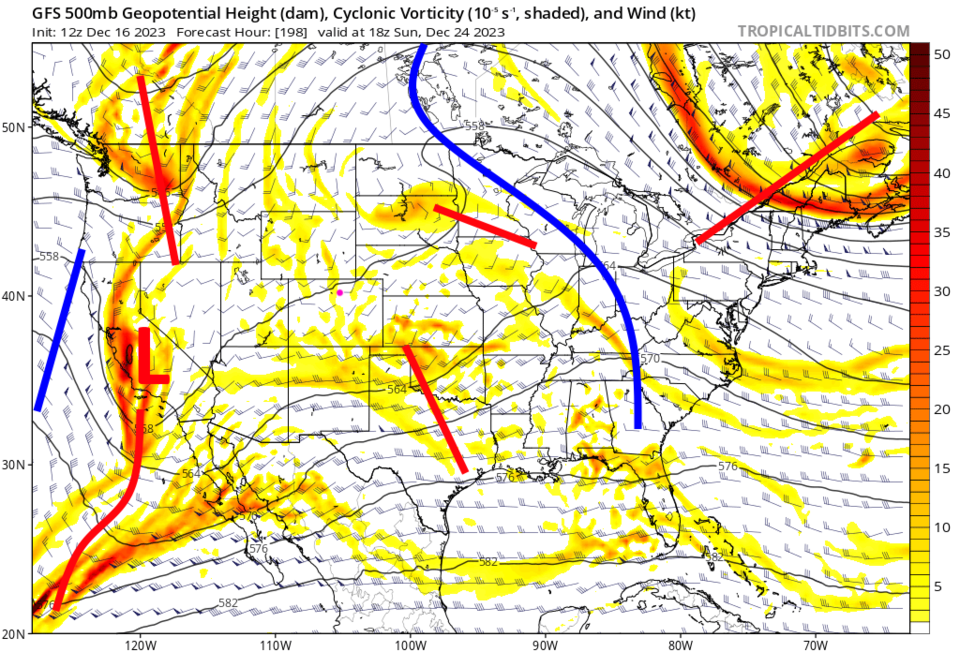
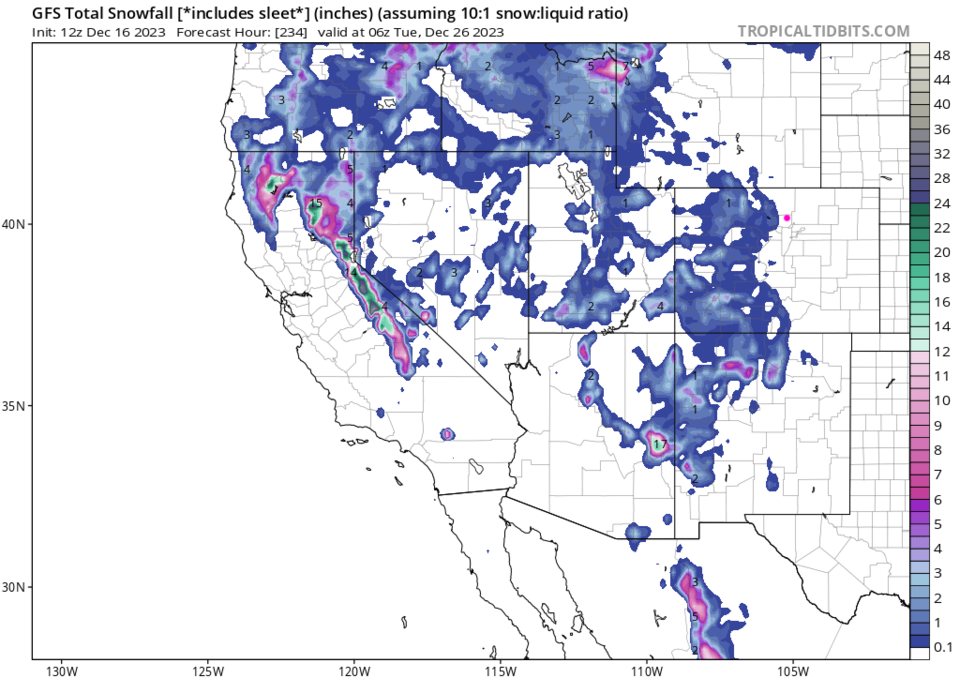
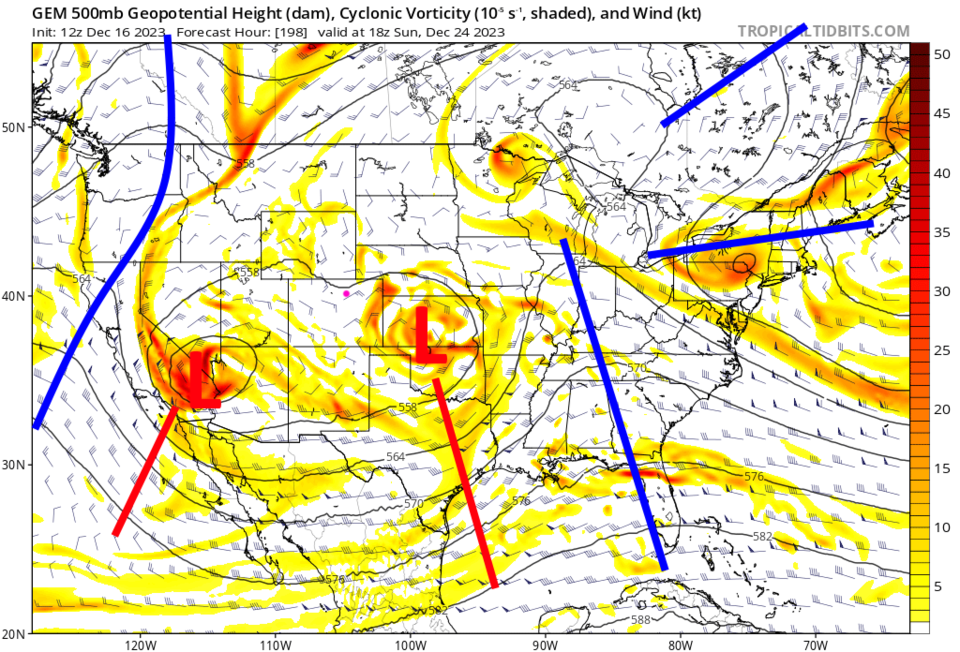
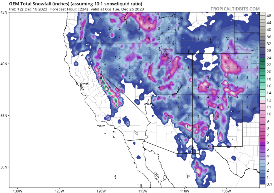
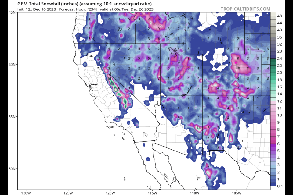
The upper air patter for Christmas Eve, from the GFS (Figure 2) is a weird mess.  I've not seen a scramble quite like this before.  It gives the mountains some snow but nothing really down to I-25 by midnight Dec 25/Dec 26 (Figure 3). The Canadian model looks more 'normal' to me (but still messy - Figure 4) and gives us a whopping 8-10 inches of snow Christmas Eve (Figure 5)!! 

This forecast is still very far away and there is a LOT of disagreement between the models.  Send a note to Santa requesting snow for Christmas! Check back here!

figure2_12162023
Figure 2: the Christmas Eve 500mb upper air forecast map from the GFS and tropicaltidbits.com
figure3_12162023
Figure 3: the GFS snowfall totals through Christmas night midnight from the GFS and tropicaltidbits.com
figure4_12162023
Figure 4: the Christmas Eve 500mb upper air forecast map from the Canadian model and tropicaltidbits.com
figure5_12162023
Figure 5: the Canadian snowfall totals through Christmas night midnight from the GFS and tropicaltidbits.com


About the Author: John Ensworth

John Ensworth used to work from Longmont as the PI for the NASA through the IGES (The Institute for Global Environmental Strategies). He now teaches technology, algebra, astronomy, meteorology, film school, and Lego robotics to middle/high school.
Read more


Comments


Current Weather

Mostly clear

Mostly clear

39°F

UV Index
0 Low
Pressure
29.46 Rising
Visibility
8 miles
Dewpoint
9 °F
Humidity
29%
Wind
NNW 4.9 mph
Gust
10.3 mph
Wind Chill
35 °F

Hourly Forecast

Today
10 PM
37°F
Partly cloudy
Today
11 PM
36°F
Partly cloudy
Tomorrow
12 AM
35°F
Partly cloudy
Tomorrow
1 AM
34°F
Partly cloudy
Tomorrow
2 AM
33°F
Partly cloudy
Tomorrow
3 AM
32°F
Partly cloudy
Tomorrow
4 AM
31°F
Partly cloudy
Tomorrow
5 AM
30°F
Intermittent clouds
Tomorrow
6 AM
29°F
Intermittent clouds
Tomorrow
7 AM
28°F
Intermittent clouds
Tomorrow
8 AM
30°F
Cloudy
Tomorrow
9 AM
34°F
Cloudy

7 Day Forecast

Mostly cloudy w/ showers

Friday

53 °F

Brief showers this morning; otherwise, cooler with clouds giving way to some sun, becoming windy this afternoon


Intermittent clouds

Friday Night

28 °F

Partly cloudy


Cloudy

Saturday

50 °F

Considerable cloudiness


Intermittent clouds

Saturday Night

29 °F

Partly cloudy


Partly sunny

Sunday

60 °F

Partly sunny, windy and milder; a nice end to the weekend


Partly cloudy

Sunday Night

37 °F

Partly cloudy; breezy late


Mostly cloudy

Monday

75 °F

Rather cloudy, becoming windier and warmer


Mostly clear

Monday Night

40 °F

Mainly clear


Mostly cloudy

Tuesday

66 °F

Turning cloudy; breezy in the afternoon


Flurries

Tuesday Night

27 °F

Breezy with a bit of snow in the evening; mostly cloudy and colder


Sunrise and Sunset

Sunrise
7:14 AM
Sunset
7:06 PM

Based on AccuWeather data