Video forecast for the week beginning September 8, 2020
Update September 7 at 8pm:
The forecast is right on track (see below). Rainfall should begin around 11pm Monday. If you have a chance, it would be good to use a hose to get ash off your car so the first light rain won't combine with the ash and create a chemical mess. This thick paste that may stain vehicle paint and coatings. Hit your vehicles with a lot of water from your garden hose and you should be good to go.
The rain should begin to change to snow around sunrise and continue through Wednesday mid-morning. Watches and warnings may be accessed in real-time at: https://www.weather.gov/bou/
Stay safe and warm!
End update September 7 at 8pm.
Update: September 6 at 6p.m.
Record heat and a bone dry atmosphere has allowed the Cameron Peak fire to flare to high levels of activity. The thickest plume of smoke and falling ash is narrow, but centered over Longmont Sunday. We are under the thickest smoke that the model includes as output (purple in Figure 1 update).
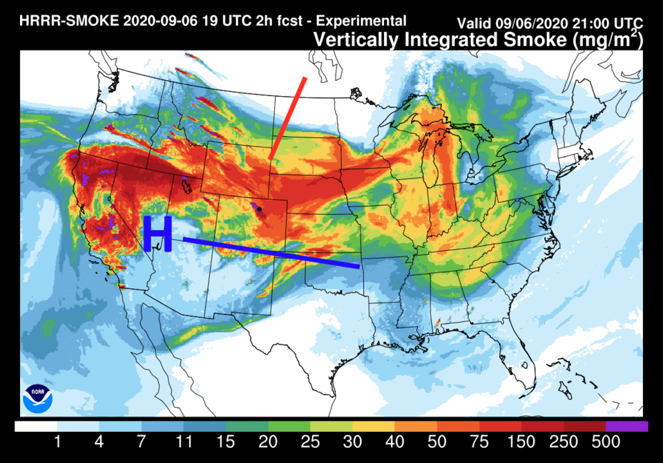 Figure 2 update: the HRRR smoke at all levels for Sunday afternoon from NOAA
Watching the future animation (not included here) - these intense smoke concentrations will continue into the night, only thinning some when the fire activity decreases overnight. It will still be fairly bad in the morning. The NWS has issued the following alert through 4 p.m. Monday:
Air Quality Alert
Issued: 4:12 PM Sep. 6, 2020 – National Weather Service ...ACTION DAY FOR PARTICULATES FROM 400 PM SUNDAY UNTIL 400 PM MONDAY...
Relief is coming in 36 hours when rain then snow arrives. Timing is still an issue. Many models are slowing the storm a bit which will make the onset of precipitation and snow later than expected but the storm could linger longer as well.
This is still predicted to be a major winter storm (in the summer) and the NWS has issued a Winter Storm Watch:
Issued: 3:37 PM Sep. 6, 2020 – National Weather Service
...WINTER STORM WATCH REMAINS IN EFFECT FROM LATE MONDAY NIGHT THROUGH LATE TUESDAY NIGHT...
* WHAT...Heavy snow possible. The Denver metro area and I- 25 corridor could see accumulations of 3 to 6 inches by late Tuesday.
* WHERE...The Front Range urban corridor.
* WHEN...From late Monday night through late Tuesday night.
* IMPACTS...Accumulating snow will impact area vegetation causing damage to trees and possible power outages.
* ADDITIONAL DETAILS...Overnight low temperatures Tuesday night into Wednesday will drop below freezing which could be harmful to crops and plants.
PRECAUTIONARY/PREPAREDNESS ACTIONS ... Monitor the latest forecasts for updates on this situation.
The GFS is still dumping a mind blowing 8-12 inches of snow on Longmont (and 12-14 inches of snow over the Cameron Peak fire - see Figure 2 update).
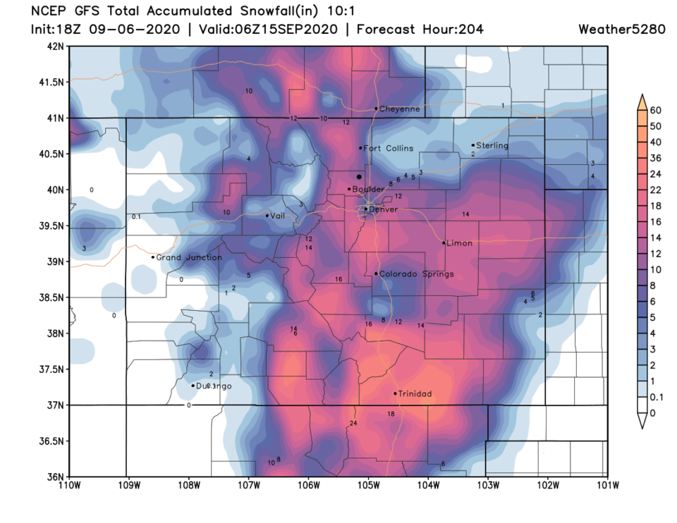 Figure 2 update: the GFS snowfall total for this week's storm from weather5280.com
I do like 3-6 inch snow totals as being more realistic from Fort Collins to Denver. All that melting will mean the best snow totals will be seen on grassy surfaces. Higher elevation roads in the foothills and mountains may become difficult to travel. As mentioned before, tree branch damage and power outages are a major concern.
In brief:
Record heat (the hottest of the summer) and a period of thick smoke will be pushed aside by a record-setting cold front around 5 p.m. Monday that brings in snow and bitter cold.
Forecast discussion:
The giant high center in the west is sitting over Las Vegas Sunday morning with a lobe of high pressure (sinking air) extending over Colorado. The wind direction in the lower atmosphere will add a sinking motion/downslope flow off the mountains Sunday (Figure 1). We should see locations on the eastern Plains hit or top 100 degrees. Smoke from Colorado and California fires will be flowing in with this heat.
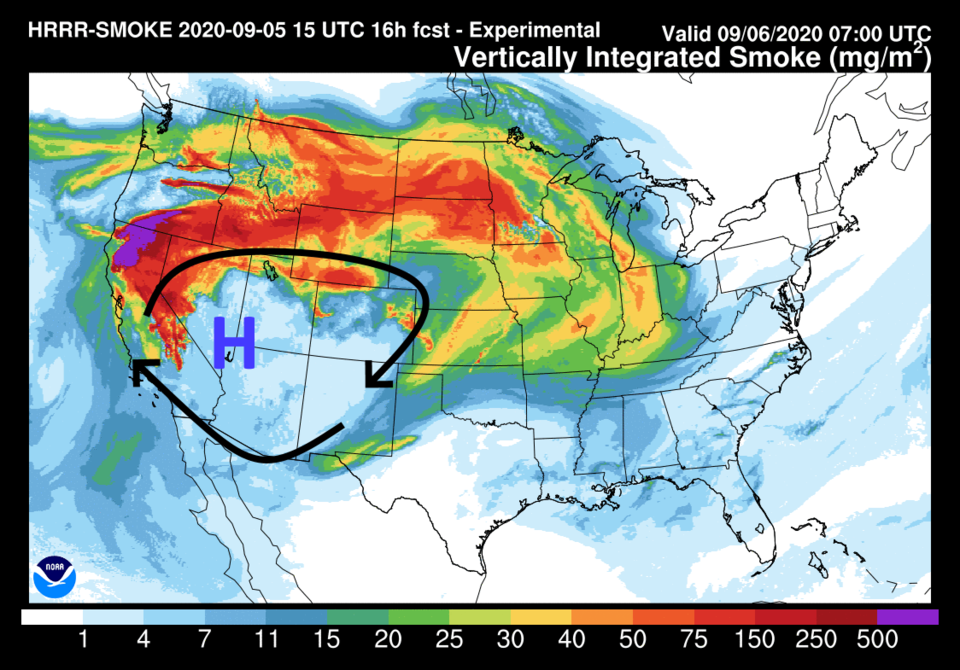 Figure 1: the HRRR smoke at all levels forecast for Sunday morning from NOAA
Change is coming though, you can see the record heat across the region Sunday afternoon with the thickest smoke shoving southward as cold clean air begins to roar out of Canada (blue arrows in Figure 2 below). The high center also is getting shoved into southern California Sunday afternoon. We should see significantly reduced visibilities Sunday and more air quality issues.
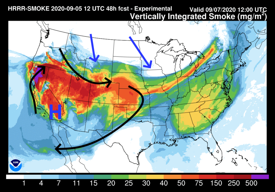 Figure 2: the HRRR smoke at all levels forecast for Monday morning from NOAA
That extreme heat (12 to 15 degrees above normal) covers the entire West and extends into Iowa (Figure 3). Dry air, heat and smoke is the story through midday Monday.
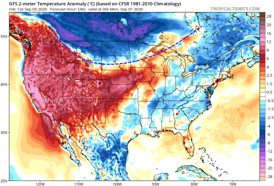 Figure 3: the national surface temperature anomaly for Sunday afternoon from the GFS and tropicaltidbits.com
 Longer-range orecast:
That cold air is being powered by a sharp, powerful cold front that pumps north winds directly down the Front Range Monday night into Wednesday (Figure 4).
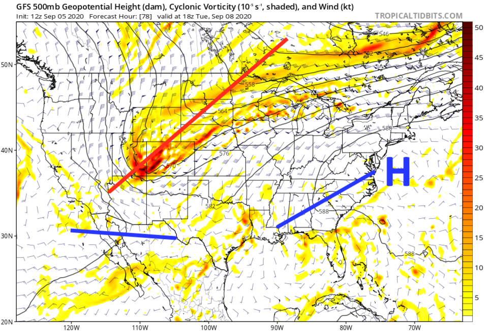 Figure 4: the 500mb forecast upper air map from the GFS and tropicaltidits .com
 Temperatures on Tuesday now look like they will drop to more than 40 degrees below normal (Figure 5). Amazing.
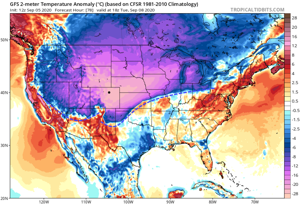 Figure 5: the national surface temperature anomaly for Tuesday noon from the GFS and tropicaltidbits.com
 Weather5280.com has a great article about how many records may be set between the weekend and Wednesday. A sampling of them are: the greatest number of 90-plus-degree days, the latest 100-degree temperature in the year, daily high and low records, the earliest freeze on record, the largest two-day temperature drop, the earliest heavy snow etc. It is worth going over there to give it a read with all the stats. Channel 9 has 12 records listed that may be met or broken.
For timing, Figure 6 shows the front now hitting around 5 p.m. Monday (though fronts like this often arrive hours earlier than the models predict). We drop from near 100 degrees on Sunday to the lower 20s Wednesday morning. We will have a hard freeze that will damage a lot of plant life.
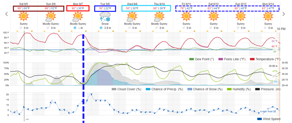 Figure 6: the 10 day graphical weather forecast for Longmont from weatherunderground.com
Snowfall roundup:
Snow should begin between 2 and 5 a..m (this could still be way off) on Tuesday. One model shows the storm lasting through Wednesday into Thursday, but most having it tapering off Wednesday morning.
The Weatherunderground.com model: 3-5 inches.
The GFS — Figure 7: 6 to 8 inches.
The NAM — Figure 8: 8 to 12 inches.
The GEM — Figure 9: 8 to 10 inches.
The NWS — rain and snow; no total given yet.
The amount of water (when melted) should end up around 0.75 to an inch total. There will be extreme melting with the hot ground temperatures. Trees all are fully loaded with leaves — they will be in danger of damage if a heavy snow load begins to build up.
With melting, my feeling is you'll see 2 to 4 inches of snow build up on grassy surfaces. A snow measurement board (how snow depth is determined officially) will see the greatest depth. This will be a hard freeze — you'll want to protect delicate plants and garden plants Tuesday and Wednesday morning.
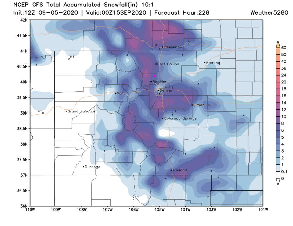 Figure 7: the total snowfall forecast this week from the GFS and weather5280.com
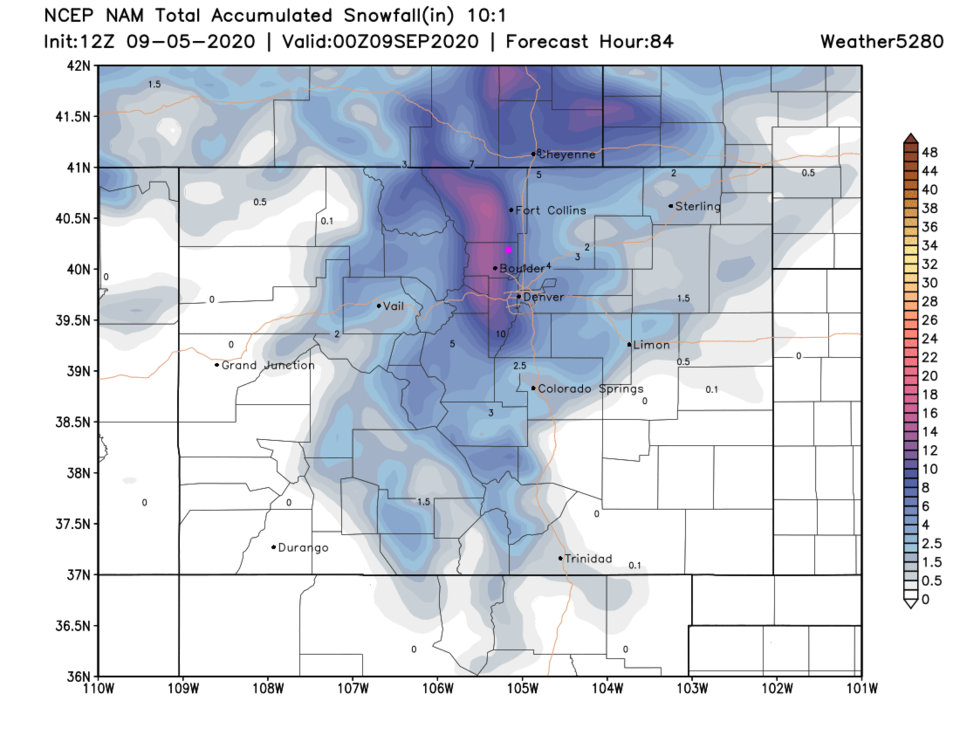 Figure 8: the total snowfall forecast this week from the NAM and weather5280.com
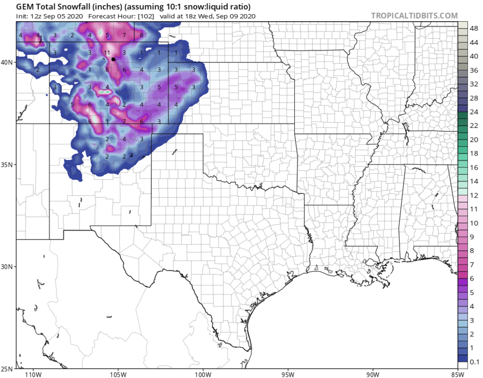 Figure 9: the total snowfall forecast this week from the GEM and tropicaltidbits.com

