
In Brief:
The hottest weather of the summer returns for the weekend, with smoke, only to be replaced Tuesday by possibly one of the biggest early season snow storms to hit northeast Colorado.
Forecast Discussion:
It was a tale of two weathers. The weather wants to join in the fun that is the year 2020. We sail into the weekend with many locations on the Plains hitting or topping 100 F for the first time. This is caused by a return of the giant ridge back east from its short stay on the west coast (Figure 1 below).
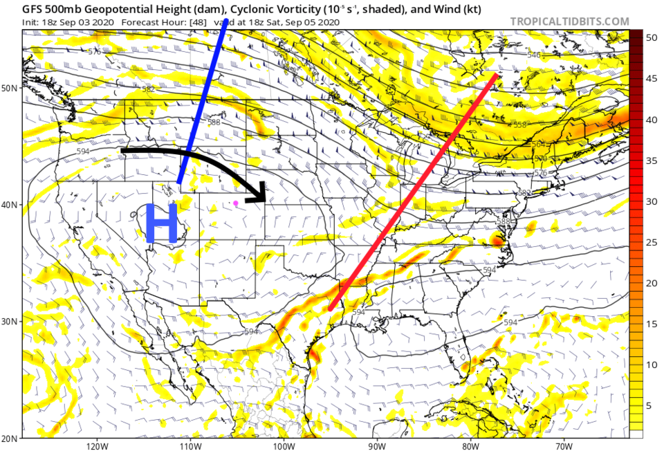 Figure 1: the 500mb upper air forecast map from the GFS and tropicaltidbits for Saturday noon.
 Of course this brings smoke from Western fires and Colorado fires back with it (black arrow in Figure 1 and Figure 2).
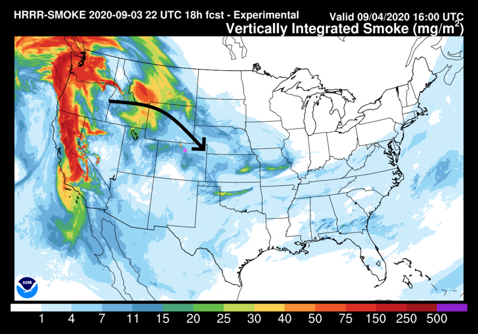 Figure 2: the HRRR smoke at all levels forecast for late morning Friday from NOAA.
The Labor Day weekend will very possibly see temperatures around Longmont hit 100 F or greater (Figure 3) with no precipitation.
 Figure 3: the 10 day graphical forecast from weatherunderground for Longmont, CO.
The Longer Range Forecast:
A bit of a cool down begins as a very powerful trough approaches us on Monday. If we hit or top 90 F that day, we will tie the 2012 record for the largest number of 90 F+ temperatures in a season. Denver has not topped 100 F yet this summer, though places along I-25 have. The temperatures Sunday will be about 20 F above normal (Figure 4).
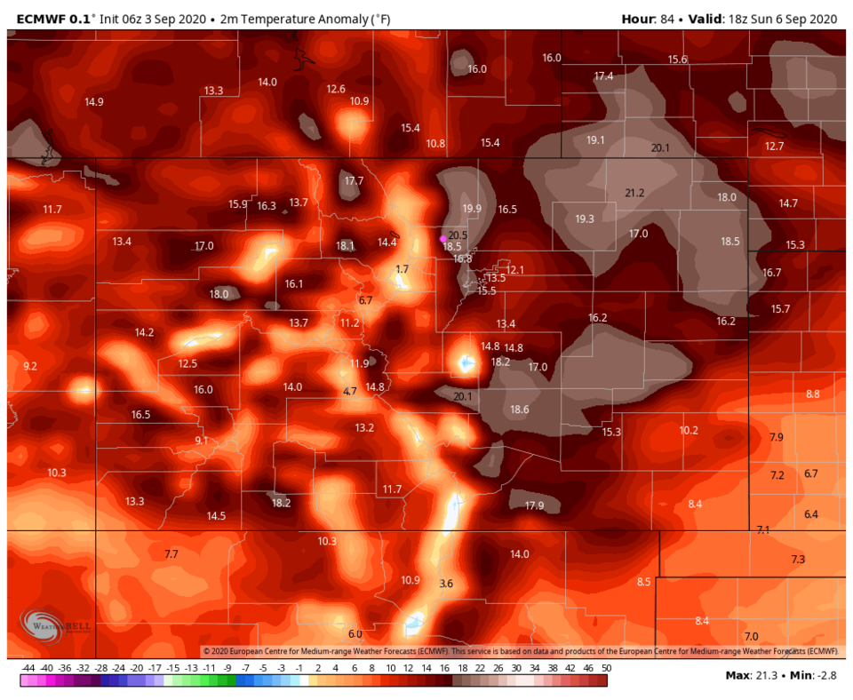 Figure 4: the surface temperature anomaly (departure from normal) from the European model and WeatherBell via Twitter for Sunday noon.
 The trough begins to arrive Monday and temperatures begin to plummet (Figure 5). This many days out, it looks like the front will hit around 3 p.m. Monday. That timing may change as we get closer.
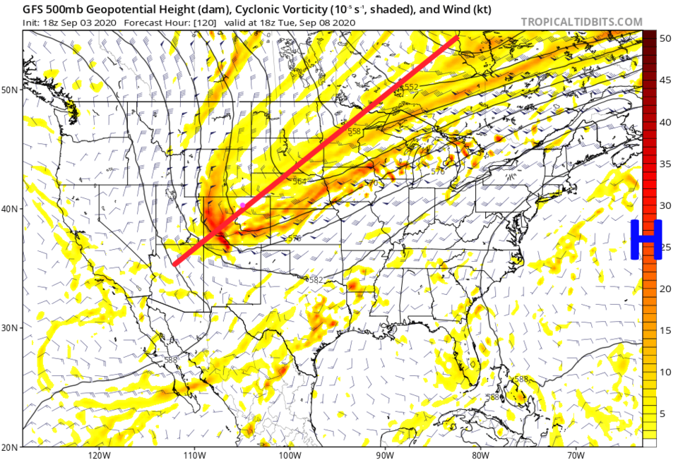 Figure 5: the 500mb upper air forecast map from the GFS and tropicaltidbits for Tuesday noon.
 Temperatures Tuesday afternoon will be around 35 F below normal (Figure 6).
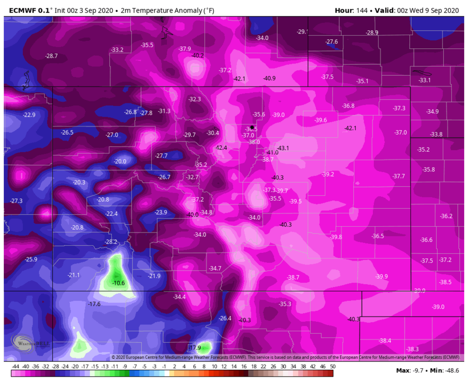 Figure 6: the surface temperature anomaly (departure from normal) from the European model and WeatherBell via Twitter for Tuesday evening.
 There is precipitation with this system as well. The GFS now gives us up to an inch of water between Monday night and Wednesday morning (future posts will narrow down the storm duration and precipitation totals - Figure 7).
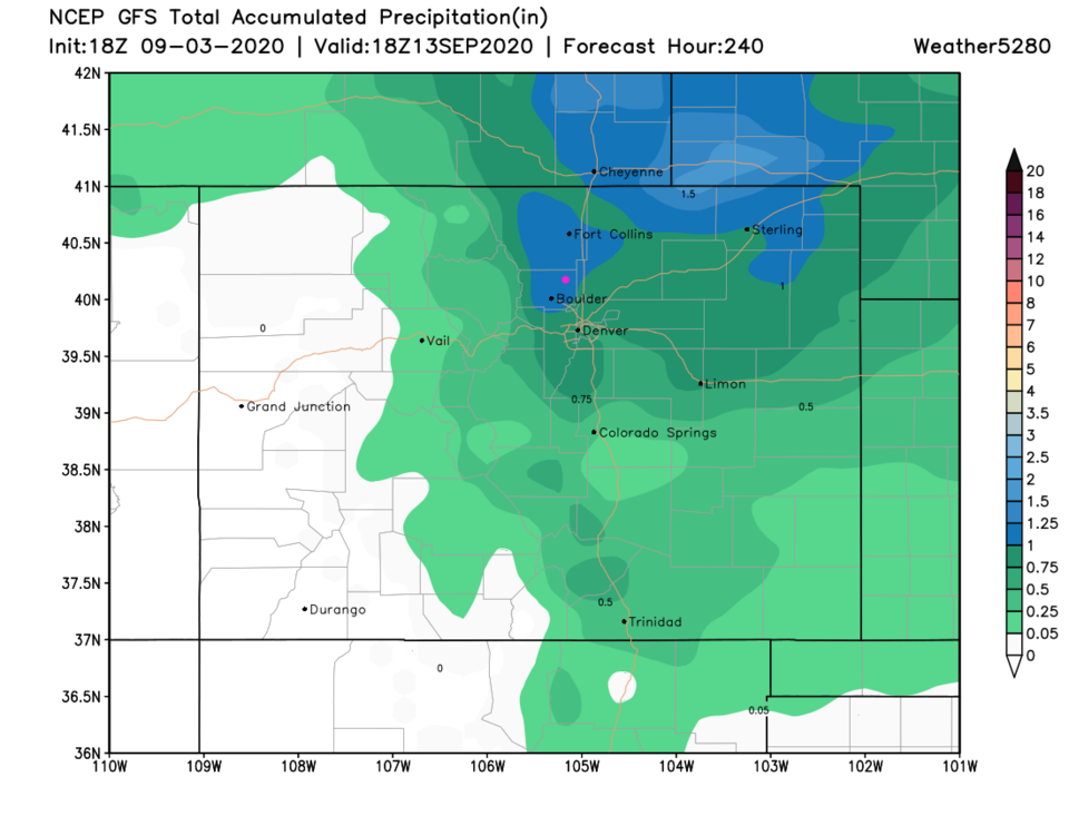 Figure 7: the total precipitation over the next 10 days from the GFS and weather5280.com
The big weather story is snow. The precipitation falling over six hours Tuesday morning includes heavy snowfall according to the GFS (Figure 8).
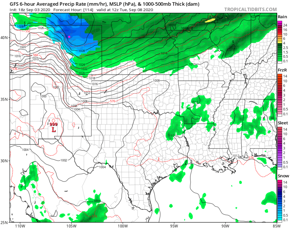 Figure 8: the surface precipitation type/intensity and surface pressure contours from the GFS for Tuesday morning from tropicaltidbits.com
Earlier this week, the models were only giving the mountain communities snow. Wednesday expectations were up to a trace of snow along I-25. As of Thursday evening, the GFS gives Boulder about 8 inches of snow while Longmont receives about 3-5 inches (Figure 9). The weatherundergound model gives us 1-2 inches (Figure 3). Of course the ground will be not just be warm, but hot. A lot of melting will occur. Grassy surfaces and (eventually) bridges will collect the larger snow depths.
Before we go, let's look at some early season snowfall stats:
- The earliest date of the first snow was September 3, 1961 (the date this is being written).
- The average earliest date is October 18th.
- We received 16.5 inches of snow September 26-28, 1936.
Note, the European model (not shown here often) gives Longmont 12-18 inches of snow and Boulder over two feet. I don't believe it will snow that much, but it is not entirely impossible. Since fall begins September 21st, this is a major summer snowstorm. Our next post will either show the storm changing back to all rain or it might show more snow than we currently expect. Stay tuned.
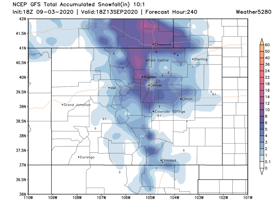 Figure 9: the total snow (10:1) over the next 10 days from the GFS and weather5280.com


