In Brief:
Normal temperatures, daily thunderstorms, a touch of severe weather - it's summer!
Update 8/3 11am:
With everything in the forecast discussion below still in play, we have a marginal risk for severe weather (mainly for hail and high winds (don't forget the ligtning risk, always)) for Monday, Tuesday and Wednesday (Figure 2 update, Figure 3 udpate, and Figure 4 update). Small variations in moisture flow and the strength of the passing upper air short waves will result in a bit more or a bit less thunderstorm coverage each day. Keep an eye on the northwest sky each afternoon (more the western sky by Wednesday).
Hurricane (breifly) Isaias is making the jump from the Florida coast to a South Carolina landfall today (Figure 5 udpate). A LOT of rain is going to drench the entire U.S. East Coast this week.
End 8/3 11am update.
Update 8/2 2pm:
The Storm Prediction Center has expanded the Slight Risk of severe weather (a 2 on a scale of 1-5) to include Longmont, Ft. Collins and spots up to Wyoming. See figure 1 update in the gallery. The primary risk this afternoon is for large damaging hail and high winds. Storms wil be scattered and moving towards you from the north or north-northwest. It is an unusual direction, keep that in mind. As always, lightning is a number one killer - beware of that as well.
End 8/2 2pm update.
Forecast Discussion:
I'll be taking one more stay-cation before the 'school' year starts. I'll be on a 3 day schedule through next weekend. To compensate, here are a record number of graphics!
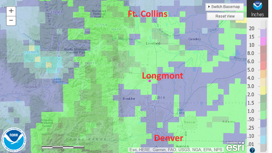
Lets start by looking back on rainfall... Figure 1 (in the gallery above) shows the rainfall across our region for the last 7 days. Longmont picked up over an inch in places just the last two evenings and much of the Front Range has seen 1/2 to 1+ inch of water. Not bad! The drought index map (Figure 2) shows that we were entering the first stage of drough conditions just before this rain came. This should help with the next map.
The big story for the West is the very high amplitude ridge over the western U.S. (Figure 3). This puts Colorado under northwest flow again - and northwest flow is famous for transporting small ripples in the upper air pattern (bubbles of cooler air) into the area kicking off storms whenever the heating of the day is present. Moisture from the Gulf in the upper air pattern is being shuttled off away from Colorado (green arrow).
The ridge axis is really creating two different worlds - as temepreatures go. Figure 4 shows the abnormal heat in the west with Arizona in record warmth territory (with south winds shown by black arrow). Even western Colorado is VERY hot. On the east side of the Rockies and the ridge, we are near normal to below normal with very reasonable tempeatures out on the Great Plains (for the start of August!) with north winds transporing cool air southward (black arrow again). This air flow continues to bring some smoke from western fires into the state from the north and northwest (Figure 5).
To get thunderstorms and rain, we need surface moisture to interact with those shortwaves traveling in the northwest flow aloft. Figure 6 is the near-surface air flow (the 850mb height is about 5000 feet above sea level). The green arrow shows how this moisture is sneaking up into the Colorado eastern Plains and foothills.
That sets the stage for a chance of severe weather Sunday and Monday (Figure 7 and 8). The primary threat will be for hail and high winds with thunderstorms. The GFS only gives us a bit of rain over the next 48 hours (Figure 10) but we saw almost an inch of rain recently because thunderstorms tracked right over Longmont. We might get lucky again.
The Longer Range Forecast:
We don't deviate far from 90F over the next week and beyond (Figure 9). We continue to have a daily chance of afternoon thunderstorms at least through mid-week. By Wednesday the ridge starts to shift east again (Figure 11). Moisture has a long trip to make from the Gulf or the Pacific. Storm chances will drop a bit. Over the next 5 days, most spots east of the continental divide will see at least some rain while a few spots will see 2 inches or more. It is the luck-of-the-thundestorm-draw (Figure 12).
Looking out to Friday, the ridge has moved eastward onto the Great Plains. We'll see a bit of warming, but also a slightly more direct moisture flow aloft (Figure 13). We'll have to watch for a return of the summer monsoon.
Tropical Check-in:
Hurricane Isaias will be the big national news this weekend. You can see it scraping Florida early Sunday morning in Figure 3. The Saturday forecast for the storm is included as Figure 14. Hurricane warnings are posted for the Bahamas and east coast of Floriday. It may effect all the major cities up the east coast through mid-week. The forecast precipitation map for the East Coast is pretty impressive (Figure 15).

