Skip to content
Join our Newsletter

High wind warning issued for west Boulder County

nws-high-wind-warning
A high wind warning has been issued for the Front Range foothills.

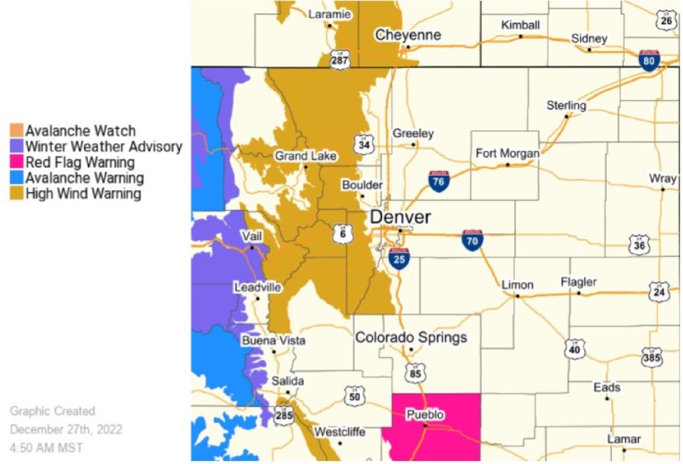
A high wind warning has been issued for the Front Range foothills, the National Weather Service announced Tuesday morning.

The warning will remain in effect until 8 p.m. Tuesday for west Boulder County, Rocky Mountain National Park, the Medicine Bow Range and Indian Peaks.

West winds of 30 to 45 mph are expected, but gusts of up to 85 mph could hit, weather officials said.

“Damaging winds could blow down trees and power lines,” the warning read. “Local power outages are possible. Travel could be difficult, especially for high profile vehicles.”

West Boulder County residents are advised to put loose objects in a safe location or fasten them down.

A winter weather advisory will be in effect from 5 p.m. Tuesday to 5 a.m. Wednesday for the mountains, and travel could be very difficult in the high mountain passes, the National Weather Service said.


Amber Fisher

About the Author: Amber Fisher

I'm thrilled to be an assistant editor with the Longmont Leader after spending the past decade reporting for news outlets across North America. When I'm not writing, you can find me snowboarding, reading fiction and running (poorly).
Read more


Comments


Current Weather

Cloudy

Cloudy

36°F

UV Index
0 Low
Pressure
29.87 Rising
Visibility
7 miles
Dewpoint
26 °F
Humidity
69%
Wind
SE 5.6 mph
Gust
11.8 mph
Wind Chill
31 °F

Hourly Forecast

Today
2 AM
35°F
Rain
Today
3 AM
35°F
Flurries
Today
4 AM
34°F
Cloudy
Today
5 AM
33°F
Cloudy
Today
6 AM
33°F
Cloudy
Today
7 AM
28°F
Partly cloudy
Today
8 AM
28°F
Partly sunny
Today
9 AM
31°F
Partly sunny
Today
10 AM
34°F
Partly sunny
Today
11 AM
36°F
Partly sunny
Today
12 PM
38°F
Partly sunny
Today
1 PM
40°F
Partly sunny

7 Day Forecast

Intermittent clouds

Friday

60 °F

Warmer with times of clouds and sun


Rain and snow

Friday Night

28 °F

A brief evening shower or two, becoming windy late with periods of rain changing to snow with little or no accumulation


Partly sunny

Saturday

42 °F

Partly sunny, becoming windier and cooler


Mostly cloudy w/ flurries

Saturday Night

20 °F

Mostly cloudy and colder with a flurry


Cloudy

Sunday

44 °F

Cloudy


Mostly clear

Sunday Night

20 °F

Clear to partly cloudy


Mostly cloudy w/ flurries

Monday

37 °F

Colder; sun and areas of high clouds in the morning, then mostly cloudy in the afternoon with a little snow with little or no accumulation


Flurries

Monday Night

12 °F

Cloudy with snow, accumulating an inch or two


Snow

Tuesday

22 °F

Colder with periods of snow


Snow

Tuesday Night

11 °F

Snow and flurries at times


Sunrise and Sunset

Sunrise
7:03 AM
Sunset
5:26 PM

Based on AccuWeather data