In brief:
Cool shots of air set the stage for a very moist, slow-moving storm that could create historic snow headaches Friday through Sunday.
Thursday AM Update:
I'll update this post one more time and start fresh tonight. It is still looking like very significant snow will fall from Colorado Springs to Cheyenne and northward. Weatherunderground composite model keep rising to a forecast I've never seen before. It is giving Longmont, basically, 20 inches on Saturday alone (Figure 6 update). I'm not comfortable predicting THAT much snow. It is normally very reliable, but it seems to going as crazy as the GFS recently (it wasn't at first).
Speaking of the GFS, Figure 7 update, it is sensing warmer air at the lower elevations just east of I-25 (with down slope warming especially between Ft. Collins and Longmont). This model is still burying everyone west of I-25 but doesn't hit the Plains until later on Sunday (after this graphic which is only up to Sunday morning).
The reason I'm stopping on Sunday morning is to compare the GFS with the NAM (which only goes out 84 hours). The NAM doesn't see temperatures inhibiting snow on the Plains but also only gives the foothills a foot of snow and the cities/I-25 5-7 inches of snow. This is a VERY different story from the crazy-town GFS. More tonight!!
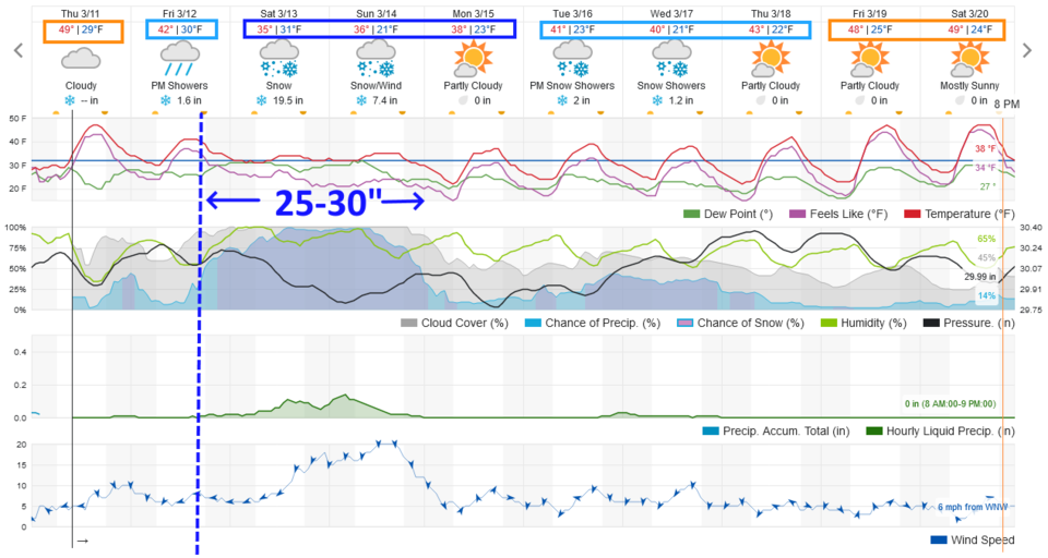 Figure 6 update: the 10 day graphical forecast for Longmont from weatheruderground.com
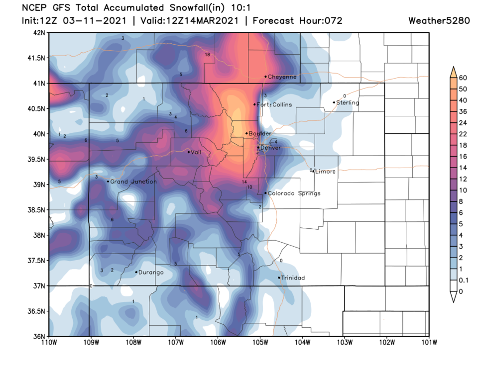 Figure 7 update: the total snowfall through Sunday AM from the GFS (1st half of the storm) from weather5280.com
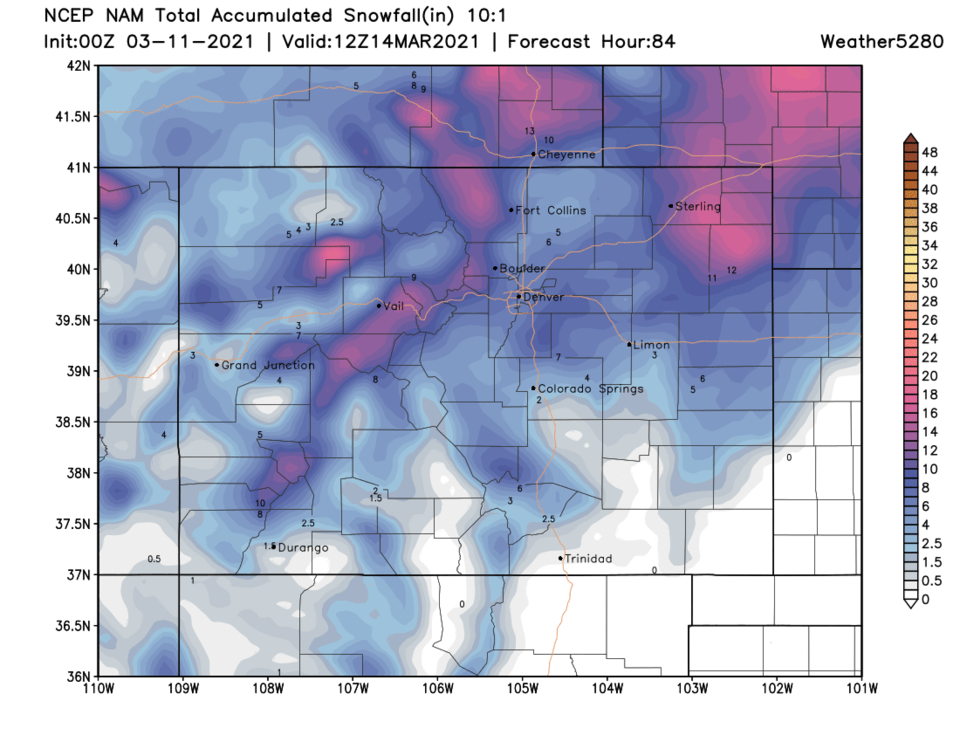 Figure 8 update: the total snowfall through Sunday AM from the NAM (1st half of the storm) from weather5280.com
End Thursday AM Update.
Wednesday PM Update:
The big storm is still on its way, rolling through the desert southwest. Temperatures at the storm start may be a bit warmer with the low center trending slightly northward, but sometime between 6-8pm (according to the weatherunderground model) snow rates will pick up quickly on Friday. When the snow rates, basically explode, the roads will become dangerous to impassable in just a few hours. There will already be 3-5 inches on the ground when the real storm starts.
Saturday will still see a foot to a foot and a half along I-25 while Sunday's 1/2 to 1 foot would be big news in any other storm (Figure 2 update). By Friday night (according to the now warmer GFS) snow will be west of I-25 by 6pm (Figure 3 update). Shortly after that, the snow will spread to lower elevations replacing rain. By noon Saturday, We'll be approaching a foot of snow almost up to I-25 and 2-5 inches east of I-25 (Figure 4 update). By noon Tuesday the region is very buried (Figure 5 update).
According to the National Weather Service:
...WINTER STORM WATCH IN EFFECT FROM LATE FRIDAY NIGHT THROUGH LATE
SUNDAY NIGHT...
* WHAT...Heavy snow possible. Total snow accumulations of 12 to 20
inches possible. Winds could gust as high as 35 mph.
* WHERE...Fort Collins, Boulder and the western suburbs of Denver,
Denver, Castle Rock, and Greeley.
* WHEN...From late Friday night through late Sunday night.
* IMPACTS...Travel could be very difficult to impossible.
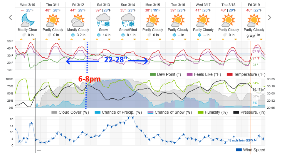 Figure 2 update: the 10 day graphical forecast for Longmont from weatherunderground.com
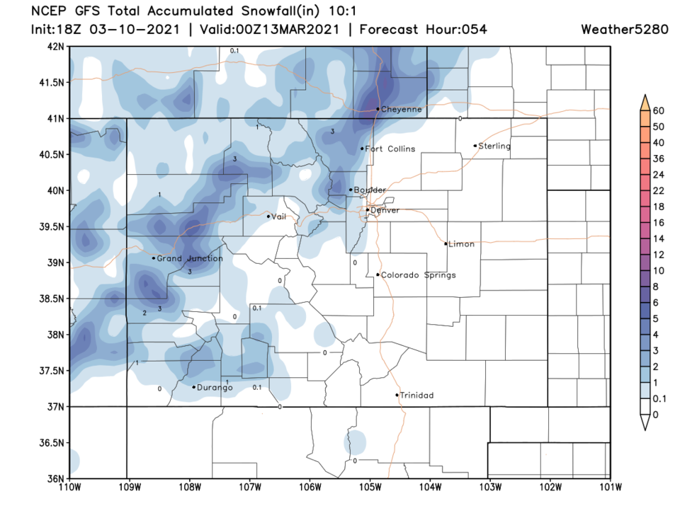 Figure 3 update: the 2-day (10:1 ratio) total snowfall forecast from the GFS and weather5280.com
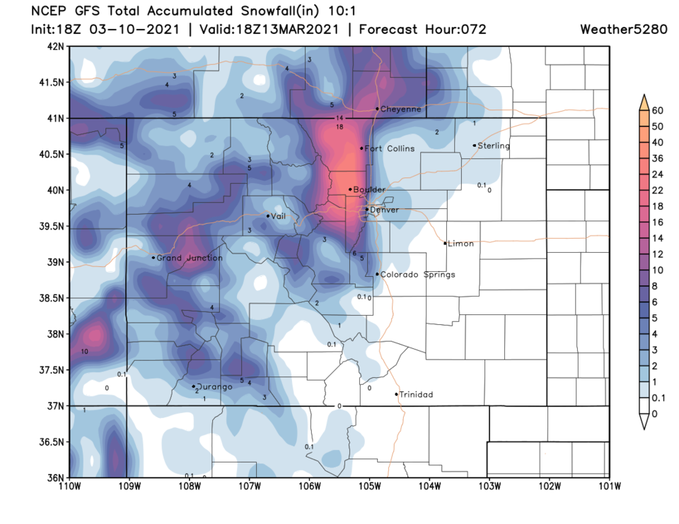 Figure 4 update: the 3-day (10:1 ratio) total snowfall forecast from the GFS and weather5280.com
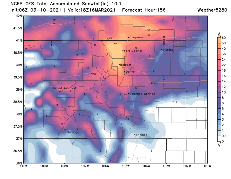 Figure 5 update: the 6-day (10:1 ratio) total snowfall forecast from the GFS and weather5280.com
End Wednesday PM update.
Wednesday AM Update:
Most of the models are increasing snow amounts from Thursday afternoon through Monday morning. The GFS (that has been extreme and crazy) has lowered lower elevation amounts to somewhat more reasonable levels (Still saying 30 to 40 inches around Longmont, which seems extreme, but not as much a few miles to the east). Figure 1 update is the weatherunderground.com model, which is a aggregation of other models, has bumped up snowfall totals for the entire period. It now gives Longmont and areas along Interstate 25 5 to8 inches by Friday night before the really heavy snowfall begins Friday night. The GFS still has an epic 60 inches throughout most of Larimer and Boulder counties (Figure 2 update). The TV stations are hopping on to the 1- to 3-foot snowfall totals and are beginning to cover this potential storm.
Note: There is still room for this storm to change path either more to the north or south, which would result in less snow (if south) and more rain than snow (and a dry slot) if it moves north.This will be interesting. Stay tuned.
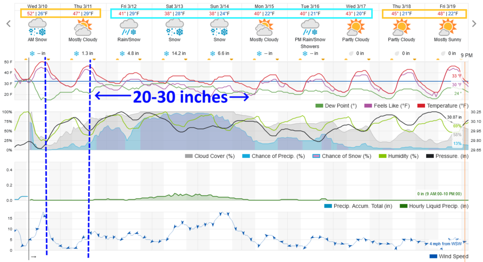 Figure 1 update: the 10 day graphical forecast for Longmont from weatherunderground.com
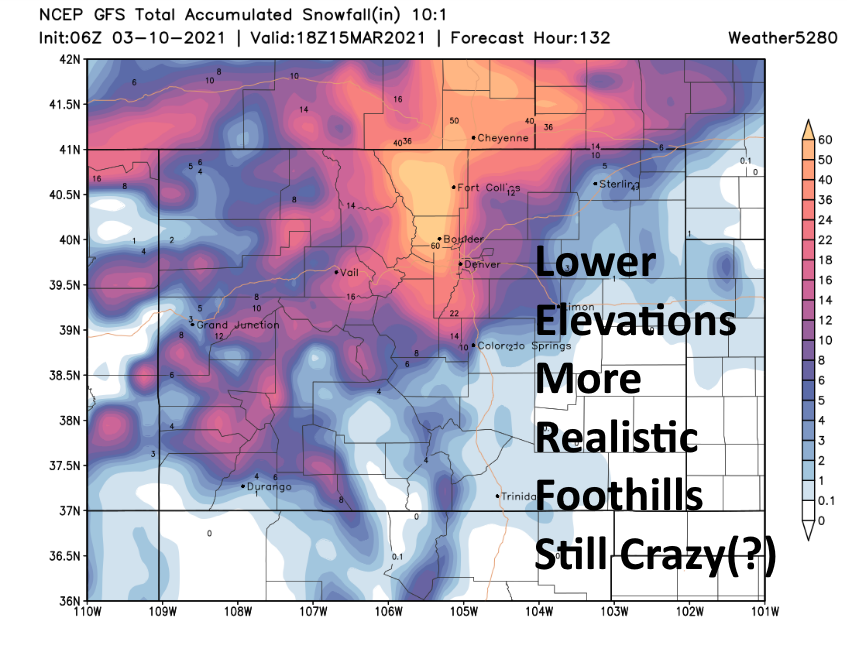 Figure 2 update: the 10:1 snowfall ratio forecast map from the GFS and weather5280.com through Monday noon.
End off the Wednesday AM Update.
The forecast discussion:
The whole story is really well told in Figure 1. The graphical forecast shows roughly three cool fronts hitting Tuesday (already past), Wednesday, and Thursday. The first hit of real snow (some may fall beforehand) comes Thursday night. We'll see 4 to 6 inches of snow on Friday after 1 to 3 inches on Thursday. Sometime Friday afternoon (commute time? Spring Break travel time?) the snow rates really begin to increase. That allows 1 to 1.5 feet of snow to add to the existing snow pack on Saturday alone. Then another 7 to 9 inches of snow hit on Sunday with a bit more snow through Tuesday. This yields an incredible amount of snow. (I've highlighted 2 to 2.5 feet Thursday through Sunday PM. in the graphic below.)
This could still be a fiction. If the low tracks north, we could see more rain and less snow and the "dry slot" may plow up the Interstate 25 corridor and kill precipitation. Basically, this far out, everything is still on the table.
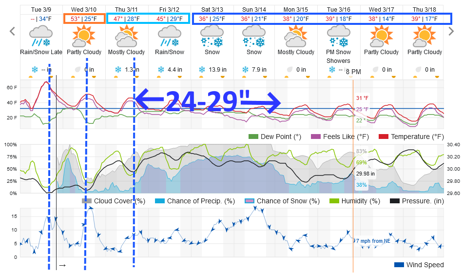 Figure 1: the 10-day graphical forecast from weatherunderground.com for Longmont, CO.
The longer-range forecast:
What we see on Saturday is a very slow-moving deep cutoff low hitting the ideal spot around the Four Corners region (according to the GFS) Friday into Saturday (Figure 2). Amazingly, this first low is only up to the Iowa region come Tuesday (Figure 3). Slow-moving is the truth.
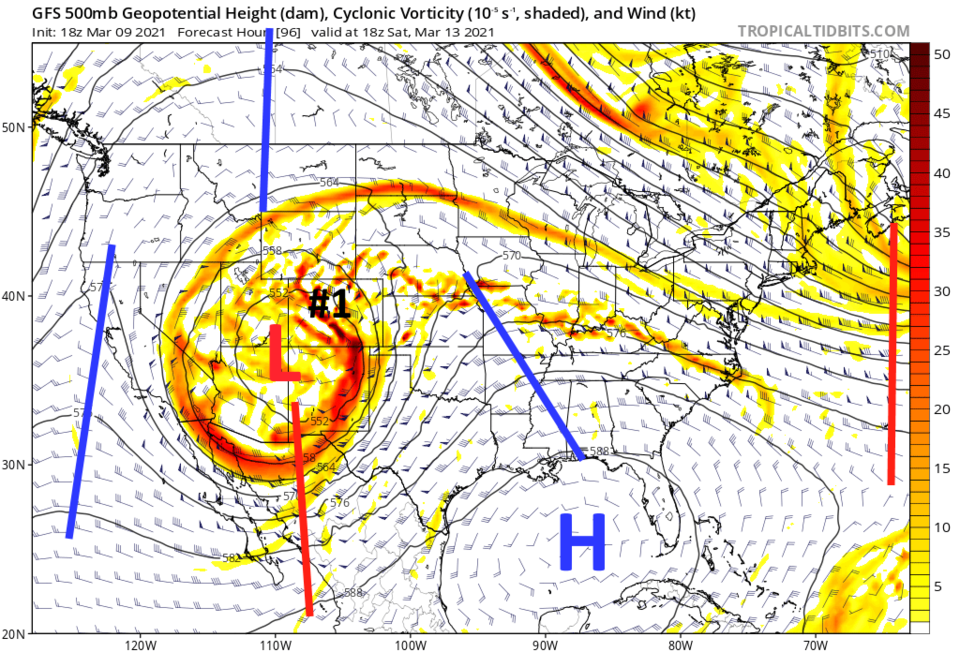 Figure 2: the 500mb upper air forecast map for Tuesday noon from the GFS and tropicaltidbits.com
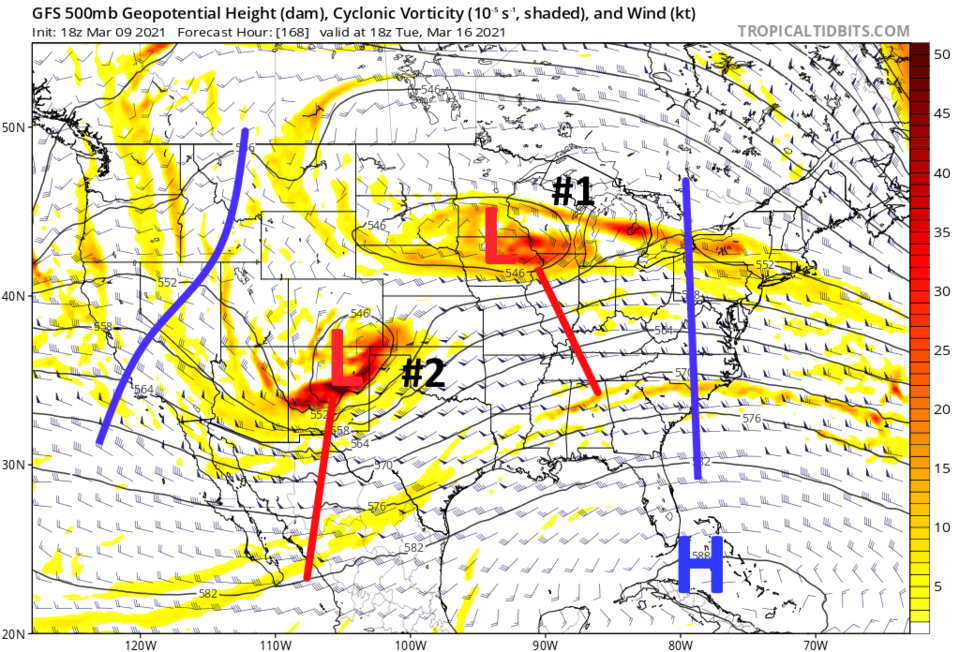 Figure 3: the 500mb upper air forecast map for Saturday noon from the GFS and tropicaltidbits.com
Snowfall roundup (so far):
Denver7 is calling for 1 to 2 feet (locally up to 4 feet in Boulder and Larimer County.) of snow by Sunday PM for the foothills and I-25 communities (not shown).
The NCEP WPC model (Figure 4) shows us getting 10 to 18 inches just west of I-25 and 4 to 8 inches along I-25 by Friday PM.
The GFS (that I still think is going too crazy, I wish it would trend toward the other models) is giving us 40 to 60 inches of snow by Sunday PM (Figure 5).
Finally, the Canadian GEM model gives us 14 to 20 inches of snow but up to 45 inches out on the eastern plains, not far from here (Figure 6).
This can only be handled by multiple updates as the weekend approaches. In the meantime, rain showers and night time snows will begin on Tuesday night into Wednesday. The warm beautiful weather is gone for now. Stay tuned.
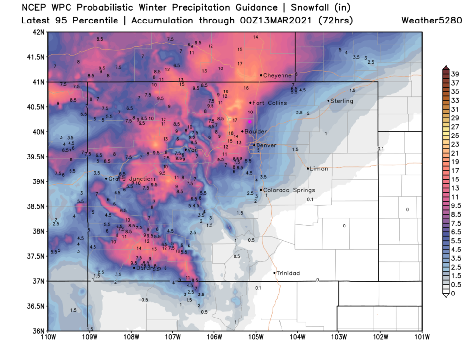 Figure 4: the 10-day (10:1 ratio) total snowfall forecast from the NCEP and weather5280.com
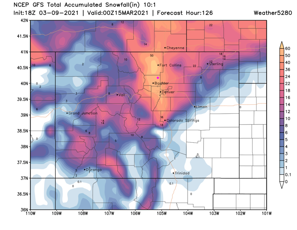 Figure 5: the 10-day (10:1 ratio) total snowfall forecast from the GFS and weather5280.com
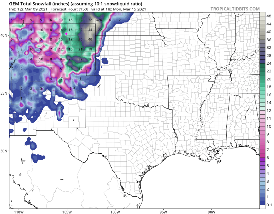 Figure 6: the 10-day (10:1 ratio) total snowfall forecast from the GEM and tropicaltidbits.com


