Skip to content
Join our Newsletter

Longmont Weather Forecast 6/23-24/2020

In Brief:

Fairly hot weather with afternoon thunderstorms is the rule except for a brief cool down and increase in storm chances Friday.

Forecast Discussion:

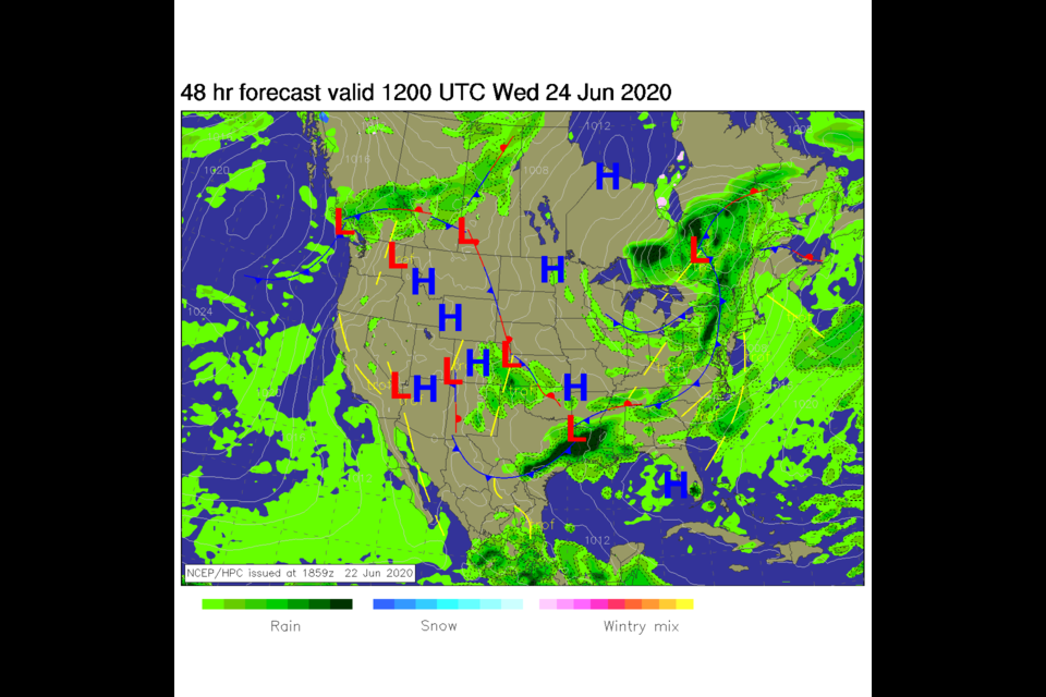
Some atmospheric moisture is sitting around Colorado this week. Daytime heating will kick off afternoon storms in the mountains and eastward (Figure 1 in the gallery). Northwest flow aloft will allow surprise enhancement of these storms to near severe levels at times (Figure 2) as small (hard to observe in advance) ripples in the flow can create more instability and lift if timed correctly. We do return to the lower 90'sF Wednesday and Thursday as the upper level ridge axis inches back towards Colorado (Figure 3 and 2).

Note, with northwest flow, the smoke from Arizona wildfires has been pushed FAR to the south (Figure 7) - whew!

The Longer Range Forecast:

Later this week, the trough out west makes a run to the east (Figure 5) bringing in a brief chance in the weather (cooler!) Thursday PM through Saturday AM (Figure 3). A fair amount of moisture gets pulled in by this system by Thursday PM into Friday AM (Figure 4).  Between the daily afternoon storms and the enhanced storminess Friday, the GFS gives us 1/2 to 3/4th of an inch of rain over the next 5 days (Figure 6). Not great but not bad.

The Video Forecast for the week beginning June 24th, 2020


About the Author: John Ensworth

John Ensworth used to work from Longmont as the PI for the NASA through the IGES (The Institute for Global Environmental Strategies). He now teaches technology, algebra, astronomy, meteorology, film school, and Lego robotics to middle/high school.
Read more


Comments


Current Weather

Mostly cloudy

Mostly cloudy

38°F

UV Index
0 Low
Pressure
29.81 Rising
Visibility
8 miles
Dewpoint
32 °F
Humidity
79%
Wind
NNE 4.3 mph
Gust
10.3 mph
Wind Chill
35 °F

Hourly Forecast

Tomorrow
12 AM
37°F
Showers
Tomorrow
1 AM
36°F
Cloudy
Tomorrow
2 AM
35°F
Rain
Tomorrow
3 AM
35°F
Flurries
Tomorrow
4 AM
34°F
Cloudy
Tomorrow
5 AM
33°F
Cloudy
Tomorrow
6 AM
33°F
Cloudy
Tomorrow
7 AM
33°F
Partly cloudy
Tomorrow
8 AM
34°F
Partly sunny
Tomorrow
9 AM
34°F
Partly sunny
Tomorrow
10 AM
37°F
Partly sunny
Tomorrow
11 AM
38°F
Partly sunny

7 Day Forecast

Intermittent clouds

Friday

60 °F

Warmer with times of clouds and sun


Rain and snow

Friday Night

33 °F

A brief evening shower or two, becoming windy late with a little rain mixing with, then changing to snow with little or no accumulation


Partly sunny

Saturday

43 °F

Partly sunny, becoming windier and cooler


Mostly cloudy w/ flurries

Saturday Night

21 °F

Mostly cloudy with a flurry


Cloudy

Sunday

42 °F

Cloudy


Mostly clear

Sunday Night

18 °F

Clear to partly cloudy


Mostly cloudy w/ flurries

Monday

37 °F

Sun and areas of high clouds in the morning, then mostly cloudy in the afternoon with a little snow with little or no accumulation


Flurries

Monday Night

7 °F

Cloudy with snow, accumulating an inch or two


Snow

Tuesday

22 °F

Colder with periods of snow


Snow

Tuesday Night

11 °F

Snow and flurries at times


Sunrise and Sunset

Sunrise
7:03 AM
Sunset
5:26 PM

Based on AccuWeather data