Skip to content
Join our Newsletter

Longmont Weather Forecast 6/20-21/2020

In Brief:

Beautiful, smoke free, mostly dry weather is the rule for the weekend and the week - enjoy!

Forecast Discussion:

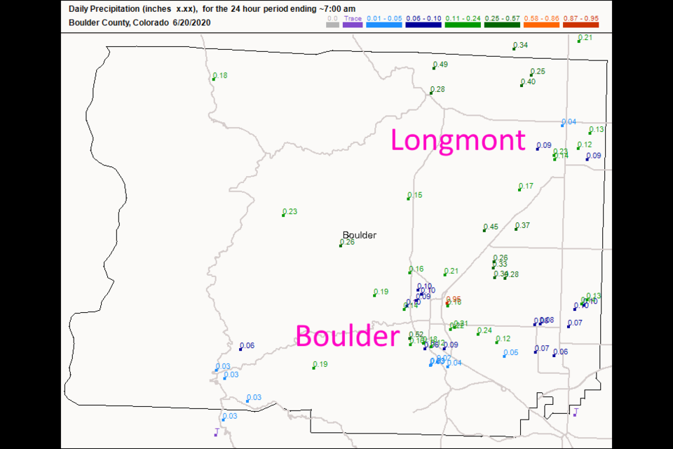
A line of thunderstorms gave us a quick dash of rain and some rumbles of thunder Friday.  Longmont picked up an additional 1/10th of an inch of rain on average bringing us to a two-day storm total of about 2/3rds to 3/4ths of an inch around town (Figure 1 in the gallery). High pressure at the surface means nice weather will continue through the weekend (Figure 2). Aloft, we have the ridge out on the west coast and northwest flow keeping us cooled to near normal (Figure 3).  This flow is serving another great function - it is blowing the Arizona wildfire smoke down into New Mexico and Texas (sorry down there).  We are completely smoke and haze free for the next few days (Figure 4).

The Longer Range Forecast:

Northwest flow will keep temperatures very close to normal early in the week (even a touch below normal).  Ripples in the upper level flow plus afternoon heating of the land and a bit of moisture will result in a daily small chance of garden variety thunderstorms Monday through Saturday.  We see a short wave ridge heat us up on Thursday and a return of the main ridge next weekend (bringing back 90'sF).   There will not be much weather-news this week

Summer Solstice! 

Welcome to the start of astronomical summer at 3:43pm Saturday.  The nights are shortest and the days longest for the year this weekend.

Forecast Video for the week beginning June 17th, 2020


About the Author: John Ensworth

John Ensworth used to work from Longmont as the PI for the NASA through the IGES (The Institute for Global Environmental Strategies). He now teaches technology, algebra, astronomy, meteorology, film school, and Lego robotics to middle/high school.
Read more


Comments


Current Weather

Clear

Clear

20°F

UV Index
0 Low
Pressure
30.1 Falling
Visibility
8 miles
Dewpoint
10 °F
Humidity
65%
Wind
NNW 1.8 mph
Gust
4.1 mph
Wind Chill
20 °F

Hourly Forecast

Today
3 AM
19°F
Partly cloudy
Today
4 AM
18°F
Partly cloudy
Today
5 AM
18°F
Partly cloudy
Today
6 AM
17°F
Partly cloudy
Today
7 AM
17°F
Hazy sunshine
Today
8 AM
18°F
Hazy sunshine
Today
9 AM
22°F
Hazy sunshine
Today
10 AM
28°F
Hazy sunshine
Today
11 AM
33°F
Hazy sunshine
Today
12 PM
36°F
Hazy sunshine
Today
1 PM
39°F
Mostly cloudy
Today
2 PM
40°F
Mostly cloudy

7 Day Forecast

Intermittent clouds

Sunday

40 °F

Sun and clouds


Mostly clear

Sunday Night

17 °F

Clear to partly cloudy


Mostly cloudy

Monday

41 °F

Sun and areas of high clouds this morning, then mostly cloudy this afternoon


Flurries

Monday Night

9 °F

Cloudy with snow, accumulating an inch or two


Flurries

Tuesday

22 °F

Cloudy and colder with a few flurries; watch for slippery spots early


Snow

Tuesday Night

4 °F

Breezy in the evening; frigid with snow and flurries at times, accumulating 1-3 inches; untreated surfaces will be slippery


Snow

Wednesday

14 °F

Occasional morning snow, accumulating 3-6 inches; otherwise, cloudy and cold; storm total snowfall 4-8"; expect slippery travel early, then some improvement


Cold

Wednesday Night

-8 °F

Mostly cloudy and very cold with the temperature approaching the record low of -13 set in 1895; extreme cold can be dangerous for outdoor activities


Intermittent clouds

Thursday

29 °F

Cold with periods of clouds and sunshine; extreme cold can be dangerous for outdoor activities


Intermittent clouds

Thursday Night

13 °F

Partly cloudy


Sunrise and Sunset

Sunrise
7:01 AM
Sunset
5:29 PM

Based on AccuWeather data