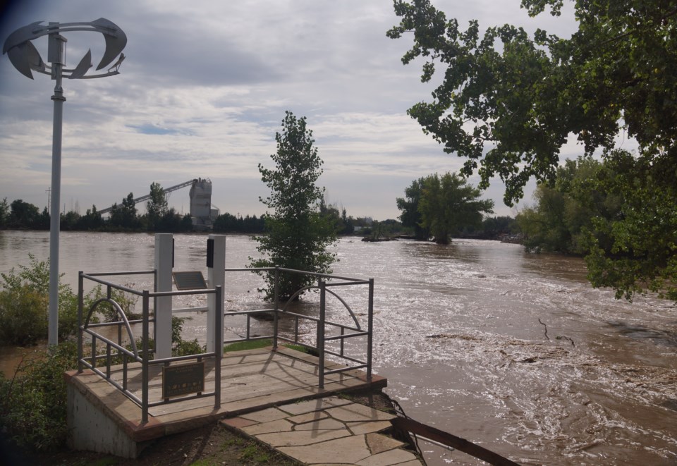
A decade has passed since the 2013 flood. The devastation from the flood reached what some consider to be a 100-year flood level. In the mountains, just west of Longmont, rainfall totals over the first four days were nearly 17 inches. The flood spanned over 150 miles from Colorado Springs to Fort Collins, claimed the lives of eight people and caused more than $2 billion dollars in damages.
In Longmont, those totals were closer to 6 inches. For 10 days, the rain would continue to fall, making efforts to connect north and south Longmont and to rebuild difficult. However, over the past 10 years, a lot has changed.
“This stream (the St. Vrain) and other streams in town could manage 6 inches of rainfall in a shot period of time. Certainly we would have experienced some nuisance flooding and some localized flooding but not of that magnitude that we experienced. It was the 14 inches of rain that also fell in the foothills and then worked their way down, and eventually made it to Longmont, that really caused the devastation,” said Josh Sherman, engineering administrator for the city of Longmont
Sherman was new to the job when the flood began. He can remember driving to Vance Brand Airport and getting on a helicopter just to get across the river to assess damages and help with relief efforts.
Prior to the flood, St. Vrain Creek needed more capacity to handle a major storm event, Sherman said. The established floodplain was outside the boundaries of the creek channel. At the time, the city of Longmont was already reviewing the impact a flood could have on the city and had funded projects to replace the Main Street and South Pratt Parkway bridges. When the flood occurred, the Main Street bridge project was in the design process.
After the flood swept through Longmont, CDOT, the state of Colorado, Longmont and other government agencies worked together to reevaluate what a major storm event actually looks like in the area. The hydraulics had not been studied since the 1950s or 1960s, Sherman said.
“We experienced some things that we expected in a flood in the sense that we had these properties that were underwater — as was indicated in the floodplain maps — but we had some things that weren’t expected,” Sherman said.
Longmont learned that prior to 2013, a 100-year storm event produced roughly 10,000 cubic feet per second of water flow at the Main Street bridge. During the flood, that number increased to 15,500 cfs.
“That’s about a 150% increase,” Sherman said.
This calculation forced the city to redesign the Main Street bridge by making it wider to pass the increased amount of water.
Dickens Farm Nature Area was determined to be a park with a tubing course before the flood. The area was redesigned in the making of the Resilient St. Vrain Project which made it a more natural area for water flow and for aquatic species to make their way downriver. This was done by removing irrigation diversions and filling nearby gravel pits, Sherman said. The city also spread out what was an eight-foot drop over several sections of the river.
The Resilient St. Vrain Project is a master plan for the St. Vrain Creek within the boundaries of Longmont and is estimated to cost $140-160 million. So far the city has completed roughly $80-100 million of work to date, Sherman said.
The work began at Sandstone Ranch and has followed the creek west. The city is in the process of working with the Army Corps of Engineers to replace the Boston Street bridge. The channel section from Boston Street up to Sunset Street is currently out to bid, Sherman said, adding construction should begin later this year.
In the November 2022 election, voters passed a $20 million storm drainage bond which will fund the project to Hover Road.
While the western boundary of the creek is Airport Road, the section between Hover Road and Airport Road does not have a plan. This area is mostly agricultural. Sherman said there are several ideas that could take place including utilizing future development projects to mitigate the floodplain in the area.
“Once we get to Hover and make these improvements, we will have removed and protected everything east of Hover on both the north and south banks of the creek that are currently within the floodplain,” Sherman said.
Sherman pointed out that no two floods are the same and should another flood happen, there will be things the city did not plan for. However, the plan was designed to provide more capacity in the creek.
“I think this project, and in general these channel improvements, are more resilient to future flooding because we have tried to account for — what we are all seeing — which is more intense and more frequent storm events and part of that is designing for that larger event,” Sherman said.
To commemorate the tenth anniversary of the flood, Longmont is hosting hourly tours of the impacted areas on Sept. 16 at 10 a.m., 11 a.m. and noon. Registration is required.
The Longmont Museum will open an exhibit dedicated to 2013 flood photos. The exhibit will open with an unveiling on Sept. 14 at 6 p.m. At 7 p.m. Motus Playback Improv Theatre will share “Stories of the Flood.”


