UPDATE 5:05 P.M.:
The CalWoodFire was at 9,978 acres Wednesday afternoon based on data gathered during a multi-mission aircraft overflight, according to an afternoon update on the posted to the CalWood and Lefthand Canyon Fires Facebook page.
The post also stated the majority of the smoke seen Wednesday afternoon in the Longmont area was from fires further to the west, including the EastTroublesomeFire.
UPDATE 12:45 P.M.:
In a cautionary move, the Boulder County Sheriff's Office on Wednesday issued an evacuation order for Lyons Park Estates.
In a Facebook post, authorities stated the "CalWoodFire remains in the current fire footprint and is not currently advancing to the north or northeast. While the northeast corner of the CalWood Fire is still within the fire perimeter and fire behavior remains moderate, the evacuation order was is issued out of "an abundance of caution," according to the post.
The order, which was issued based on observed fire behavior observed and the winds forecast for later in the day, is intended to "allow residents time to safely evacuate and prevent any evacuations being needed in the middle of the night," according to a post on the Boulder County Office of Emergency Management website.
"Deputies are currently going door-to-door making notifications to all Lyons Park Estates residences," according to the post, which was made at 11:56 a.m. "As a reminder, all residents being evacuated should think about any winterization that needs to be completed to their property due to the possible incoming winter weather. Any evacuee who needs a hotel voucher can go to the Evacuation Coordination Center at 1333 Iris Ave., which is located in Boulder County’s North Broadway Health & Human Services campus at the corner of Broadway and Iris in Boulder.
Evacuating residents are asked to travel east on Colo. 66 to North 75th Street and then take the Diagonal Highway south into Boulder.
View a video briefing on the evacuation order here.
***
The CalWood fire in western Boulder County was burning 9,915 acres as of early Wednesday morning and containment remained at 21%.
The fire perimeter can be viewed on an interactive fire map, which was updated after an overnight infrared flight, authorities stated in an update posted to the CalWood and Lefthand Canyon Fires Facebook page at 6:48 a.m.
The map, which also includes the perimeter of the Lefthand Canyon fire, allows people to input an address to see where the fire perimeter is in relation to their locations. It also includes a tool that allows people to measure the distance from a specific address to the fire.
In a video briefing posted at 9:34 a.m., Josh Shroyer, planning operations trainee, said containment was increasing along the east side of the CalWood fire and along the U.S. 36 corridor. In his briefing, Shroyer said a full night shift would be in place Wednesday so there would be 24-hour coverage on the fire.
The Lefthand Canyon fire on Wednesday was burning 459 acres and was 4% contained. That total is down from the 470 acres reported Tuesday afternoon. The reduction in acreage is due to better mapping, according to authorities. Shroyer in his video briefing said fire crews have good containment lines all the way around the fire, which they are working to improve and all day they will continue to mop up and address hot spots. A crew also will work the fire overnight, he said.
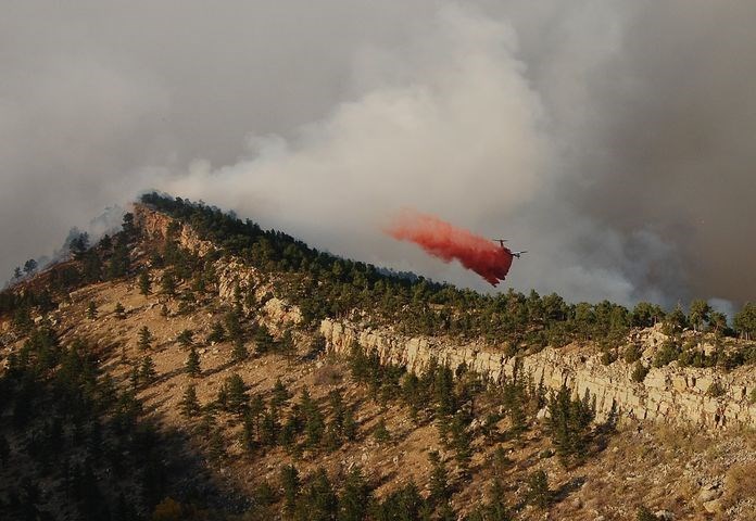
Winds kept aircraft grounded Tuesday morning, but as the winds died down aircraft were able to assist ground crews in the afternoon and crews made progress on constructing fire lines on both blazes, fire officials stated.
Fire officials expect more critical fire weather conditions on Wednesday with strong winds and gusts of up to 30 mph and low relative humidity, incident meteorologist Derek Williams said at a virtual community meeting Tuesday night. The weather conditions expected Wednesday mirror those that helped fuel the explosive fire growth over the weekend, he said, and red flag warning has been issued for the fire area. Red flag conditions are expected from noon Wednesday through 8 a.m. Thursday, according to Williams.
The forecast does offer hope in the coming days, with a strong cold front expected to move through Colorado and over the fire area Thursday morning, Williams said. "In fact, our high temperatures will be reached Thursday morning, in the 50s, and from then temperatures will drop, relative humidity will rise and winds will diminish especially Thursday night into Friday," he said.
Another strong storm system on Saturday and Sunday will provide a good opportunity for accumulating snowfall not only in mountains but on the plains, with snow totals from 2 to 5 inches, Williams said.
"We'll keep an eye on that and see how it plays out, but it is looking good for snow over the weekend timeframe," he said.
Nearly 3,000 people have been forced to evacuate the area because of the CalWood fire that was first reported Saturday afternoon. The number of structures burned remained at 26 on Monday, according to officials. However, the far western section of the burn area was still too active for the assessment team to reach.
The Lefthand Canyon fire, which was reported on Sunday, forced the town of Ward to evacuate.
Evacuation zones, as well as areas under evacuation warnings and road closures, can be viewed here.
The fires, and others burning across the state prompted the closure of U.S. Forest Service lands spanning the Front Range at midnight Tuesday.
The temporary closure applies to all national forest land in Clear Creek, Jefferson, Gilpin, Boulder and Larimer counties, according to a Forest Service news release. The closure will be re-evaluated daily.
As of Tuesday morning, nearly 442,000 acres of land were affected by wildfire across north central Colorado and southern Wyoming, the Forest Service stated in the release, citing data from the Rocky Mountain Coordination Center.
See a consolidated map of closures on the Arapaho and Roosevelt National Forests here.
The next video briefing on the CalWood and Lefthand Canyon fires is slated to be posted to the Facebook page at 9:30 a.m., with brief updates also slated to be posted at noon, 5 p.m. and 8 p.m.

.jpg;w=120;h=80;mode=crop)
